Red River of the South
It forms much of the eastern border of Miller County, Arkansas, turning south near Fulton and flowing into Louisiana, where it feeds the Atchafalaya River.
[citation needed] The Red River begins at the junction of Buck Creek and Prairie Dog Town Fork, in Harmon County, Oklahoma.
Originally called Greer County, Texas, the US Supreme Court ruled that it belonged to the United States, which at the time oversaw the Oklahoma Territory.
[5] The southern fork, about 120 miles (190 km) long, is generally considered the main stem of the Red River.
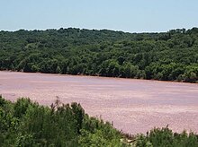
Beyond the dam it runs generally east towards Arkansas, receiving Oklahoma's Muddy Boggy Creek on the left bank before turning southward near Texarkana.
[citation needed] Native American cultures along the river were diverse, developing specialized adaptations to the many different environments.
[5] Starting near the headwaters, the Plains division of the Lipan Apache dominated the western Red River area until the 18th century, when they were displaced by invading Comanche from the north.
[5] By the time of European contact, the eastern Piney Woods of the lower river courses were dominated by the numerous historic tribes of the Caddo Confederacy.
Jefferson wrote in a letter to explorer William Dunbar that the river was "in truth, next to the Missouri, the most interesting water of the Mississippi".
[10] Having threaded the maze of bayous at the river's confluence and the "Great Raft" of lodged driftwood, the expedition was stopped by the Spanish near present-day New Boston, Texas.
In April 1815, Captain Henry Miller Shreve was the first person to bring a steamboat, the Enterprise, up the Red River.
Fulton and Livingston, who claimed the exclusive right to navigate Louisiana waters by steamboat, sued Shreve in the District Court of New Orleans.
That decision, along with a similar outcome in Gibbons v. Ogden, freed navigation on every river, lake or harbor in the United States from interference by monopolies.
[12] When John Quincy Adams became Secretary of State in 1817, one of his highest priorities was to settle with Spain the boundaries of the Louisiana Purchase.
The treaty defined the south bank of the river as the boundary between the United States and Spain, as of when it was surveyed and demarcated following 1819.
Confederate commander Richard Taylor succeeded in repelling an army under Nathaniel Banks that was three times bigger than his own.
In the early 19th century, settlers found that much of the river's length in Louisiana was unnavigable because of a collection of fallen trees that formed a Great Raft over 160 miles (260 km) long.
[16] In 1943, Denison Dam was built on the Red River to form Lake Texoma, a large reservoir of 89,000 acres (360 km2), some 70 miles (110 km) north of Dallas.