Redland City
With a population of 159,222 as of June 2021, Redland City is spread along the southern coast of Moreton Bay, covering 537.2 square kilometres (207.4 sq mi).
[3] Despite this status, Redland City consists largely of suburban and coastal communities, featuring a somewhat disjointed urbanisation around major suburbs interspersed with bushland.
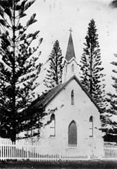
[5] Some locations derive their names from Aboriginal languages, and known historic sites within the area include a bora ring at Mount Cotton.
By the 1840s, the coastal township of Cleveland was in contention to become a major port replacing Brisbane, but was ultimately not chosen due to the region's existing sandbars and shipwrecks, and an unfavourable review from Governor George Gipps during his 1842 visit.
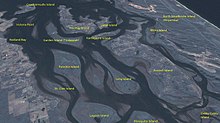
[16] Although most of the population resides on the main urban conglomeration based around the centres of Capalaba, Cleveland and Victoria Point, over 6,000 people live on islands in Moreton Bay that are part of the city.
Tingalpa Creek rises on Mount Cotton, forming Leslie Harrison Dam, and marking the majority of the area's western boundary.
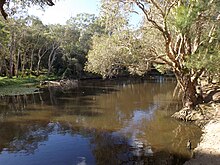
[17] Redland City has many immediately recognisable animals and plants such as koalas, migratory shorebirds, flying foxes and scribbly gum forests.
It is also home to over 1,700 other recorded native species, many of which are under threat from population growth and its associated effects such as habitat clearing and fragmentation, road construction, pollution and expanding development.
Tidal flats, mangroves and seagrass beds provide important habitats for fish, crustaceans, and: Freshwater systems in the Redlands catchment do not meet set ecosystem health values, according to the Healthy Waterways Report Cards for both 2013 and 2014.
[26][27] Fire ants have been detected in a number of Redland City suburbs, with Sheldon and Mount Cotton being assessed by BioSecurity Queensland as high-risk, and requiring treatment by ground teams.
Northern suburbs of the city are serviced by five stations: Thorneside, Birkdale, Wellington Point, Ormiston, and Cleveland, where the line terminates.
Bus stations at Capalaba and Victoria Point feature regular city-bound and outbound connections, with direct services to Carindale, Eight Mile Plains, Loganholme, and the Brisbane CBD during peak hour.
[34] Key industry sectors include health care and social assistance, retail trade, education and training, sand mining, construction and tourism.
[38] In 2010, Queensland's Labor Government announced a phase-out of the sand mining industry over a 17-year period, with up to 80% of the island to be covered by national park.
[42] On 6 June 2014, North Stradbroke Island's traditional owners, the Quandamooka people, initiated a legal challenge saying, on the grounds that the LNP Government's extension of mining contravened the Federal Native Title Act.
[44][45] Mainland quarries are located in the suburb of Mount Cotton,[46][47] and have drawn their own criticisms concerning allegations of pollution[48] and OHS breaches.
PDA designation allows development to be fast-tracked, but also means that local communities and interest groups have less opportunity to comment on issues of concern.
[51] On 4 March 2014 a petition with 1,211 signatures calling for the Government's Toondah Harbour PDA plan to be withdrawn was tabled in the Queensland Parliament.