Regional Natural Park of the Ardennes
This includes 54 areas of ecological, faunal, and floral interest, as well as seven Natura 2000 sites, forests, peat bogs, heathlands, dry grasslands, slate quarries, rocky cliffs, deep valleys, and bocages.
An information campaign and consultation process were organized,[3] with clear communication that the park would not interfere with agricultural, forestry, or industrial development, and that hunting and fishing would continue as usual under existing regulations.
Additionally, the committee includes many advisory members, such as representatives from the Regional Economic, Social, and Environmental Council [fr] and the "Friends of the Park" association.
[20] The Ardennes PNR was established during a period of reduced state financial support, and it relies on a team comprising administrative staff and seven project managers who specialize in areas defined by the charter.
[26] At the base of the Ardennes Massif, along a band extending from Signy-le-Petit and Rumigny to Renwez and Warnecourt, the Lias Sea deposited layers of sand, clay, and limestone, which were later inhabited by large reptiles.
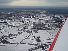
The landscape of the Givet point is distinguished by a topography comprising hills, and forests, which at times give way to cultivated lands, rocky outcrops, and dry grasslands.
[37][38] To the east of this plateau is the highest point of the massif, Croix-Scaille, which reaches an elevation of 504 meters above sea level and is situated on the border between France and Belgium.
[36] The Rocroi Plateau [fr] reaches elevations between 360 and 380 meters and is distinguished by its highly saturated soil, which is home to a multitude of "rièzes" (peat-rich heaths).
[43] In his writings, Jules Michelet described the region as a "cold, uniform, and wild country, which travelers find ugly and whose monotonous sadness lends it a touching charm for those who were born there.
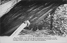
[45] These formations can be classified into the following categories:[46] The Roche à Sept Heures site in Monthermé, which offers a vantage point over the Meuse valley, also serves as the entrance to an underground slate quarry.
The Sormonne Valley was formed by the erosion of the Lias layer on the edge of the Ardennes Massif, creating a corridor of meadows and cultivated plots, interspersed with hedgerows and orchards.
The buildings are characterised by a high degree of regularity, with structures aligned in a linear fashion, facades crafted from white limestone, and gabled roofs clad in slate.
The lower precipitation levels observed in the Pointe de Givet can be attributed to its position to the northeast of the Rocroi massif, which acts as a barrier, preventing some of the moisture from westerly winds from reaching this area.
The expertise in metalworking has facilitated the establishment of innovative companies, including Les Ateliers de Janves, Nexans, NPL, Faynot, and others, which have succeeded historical businesses.
Manufacturing activities producing nuts and bolts are still ongoing in Bogny-sur-Meuse through small and medium-sized enterprises (SMEs),[75] often specializing in specific products (Affel'm, Marbaise, Cousin-Malicet, etc.).
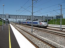
The introduction of high-speed rail connectivity with the gateway city of Charleville-Mézières and the gradual expansion of the motorway network is contributing to the region's integration into the broader economic landscape, reducing its isolation.
[61] The Renwez Forest Museum [fr] provides insight into the nature of this activity a century ago, illustrating its substantial impact on the regional economy and society.
The region is home to a variety of large mammals, including the red deer and wild boar, which has been identified as an emblem of the former domain of the Celtic goddess Arduinna.
[98] The flora of the acidic meadows in the Sormonne Valley is notable for its prevalence of stiff matgrass, purple moor grass, common lousewort, and creeping willow (a protected species), which coexist with daffodils, devil's-bit scabious, and other spotted orchids.
[91][100]The Ardennes Regional Natural Park is a popular destination for tourists, accessible via the Trans-Ardennes Greenway [fr], a cycle touring path along the Meuse River, as well as cyclocross trails that traverse forests and slopes.
[101] The region's hills and valleys have been inhabited since prehistoric times, as evidenced by the presence of dolmens and burial chambers, such as the covered alley at Giraumont [fr].
[102]To protect themselves, the locals constructed fortified churches, particularly in the Thiérache Ardennaise region, including those in Cliron, Tournes, Signy-le-Petit, Fligny, Tarzy, Bossus-lès-Rumigny, Antheny, Flaignes, Hannappes, Prez, and Liart.
The legacy of artisanal and industrial activities is also significant, evident in the numerous workshops, former forges, factories, and owners' houses (sometimes located in seigneurial castles) that have left an imprint on the region.
Additionally, the workers' homes, such as those in Laifour, at the entrance to the commune from Deville, in the place called Madagascar,[70] the Paris-Campagne town [fr] in Revin,[105] or the L'Échelle estate in Bogny-sur-Meuse, serve as tangible reminders of the region's industrial past.
[106]The culinary heritage of the Ardennes Regional Natural Park encompasses a variety of fish and game dishes, which are available in inns situated along the Trans-Ardennes Greenway [fr].
One might consider following the example of Georges Simenon,[N 4] who conducted meticulous research on traditional Ardennes cuisine, small restaurants, and dining tables in the Meuse Valley.
Additionally, one could visit the farmers' markets in Renwez or Maubert-Fontaine, gain access to farm inns, appreciate the local varieties of fruit trees, and interact with various breeders, such as those raising the red Ardennes turkey [fr] in Auge and its surrounding area.
[114][115] "As a child in my native Ardennes, I was fascinated by tales and legends", states Pierre Dubois, author, and founder of elficology [fr],[116] who hails from Charleville-Mézières.
A biennial festival, Le Printemps des Légendes [fr], was established in Monthermé to preserve the oral tradition and legends associated with the region.
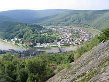
[121] In 1842, Victor Hugo, en route to the Rhine, took the opportunity to recount his experiences in Givet, the Charlemont rock, and the surrounding landscapes in a letter imbued with a touch of humor.