Regions of Sydney
The metropolis of Greater Sydney in New South Wales, Australia, is informally subdivided into a number of geographic regions.
The geographical definition of Greater Sydney spans across 33 local government areas and includes the Blue Mountains in the west, the Northern Beaches and the Hawkesbury in the north, the Royal National Park, the Wollondilly and Macarthur in the south, and Botany Bay in the east.
For government planning purposes, the metropolis of Sydney is divided in other ways, including into "districts" or "cities".
[1] Described as the City of Suburbs, the "regions" of Sydney acquired their distinct social-geographical characteristics as a result of successive waves of development and suburbanisation, as well as geography.
In the late 19th century, certain parts of those two regions were recognised as the premier residential areas of the emerging metropolis.
The building of the Sydney Harbour Bridge led to rapid development of the Lower North Shore region, and soon after, the Upper North Shore and Northern Beaches, as new developments with large houses on generous lots appealed to residents seeking the "picturesque suburb" lifestyle.
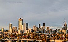
Together with the oldest suburbs in the East and Inner West, these regions still contain the most desirable residential areas of Sydney: as of the end of 2021, the 20 most expensive postcode areas in Australia (measured by median house price) were all in metropolitan Sydney, and included nine in the Eastern Suburbs, four on the Northern Beaches, two on the Lower North Shore, three on the Upper North Shore, one (straddling Hunters Hill and Woolwich) in Northern Sydney and one (Strathfield) in the Inner West.
[6] At the same time, the arrival of the suburban railway around the end of the 19th century led to development of existing towns and villages into new urban centres outside the traditional metropolis, such as Parramatta, Bankstown and Liverpool.
[8] The 1951 County of Cumberland planning scheme attempted to rein in urban sprawl by designating an expansive "green belt", which would have limited further urbanisation beyond the already-urbanised parts of Western Sydney.
This includes the entirety of the local government areas of Waverley, Woollahra and Randwick as well as the eastern parts of the City of Sydney and Bayside Council.
The region roughly corresponds with the cadastral Parish of Botany as well as the Federal Division of Kingsford Smith.
[12] Suburbs usually regarded as being in the Inner West region include Abbotsford, Ashbury, Ashfield, Balmain, Burwood, Concord, Dulwich Hill, Five Dock, Glebe, Homebush, Hurlstone Park, Leichhardt, Lilyfield, Marrickville, Newtown, Rozelle, Strathfield and Summer Hill.
Fairfield, Parramatta, Canterbury-Bankstown, City of Hawkesbury, the Hills Shire and Penrith are no longer WSROC members, although these local government areas are still regarded as part of Greater Western Sydney.
Some suburbs across different local government areas in this region include Granville, Doonside, Cabramatta, Windsor, Wentworthville, Glenorie, Westmead, St Marys, Kellyville and Edmondson Park.
It covers the suburbs extending north-west from southern Canterbury, to the south of Lidcombe and north-east from Bankstown.
The Upper North Shore usually refers to all suburbs within the local government area of Ku-ring-gai, and a small area of Hornsby Shire, situated between Lane Cove National Park and Ku-ring-gai National Park, or suburbs between Boundary Street, Roseville, the M1 Motorway in Wahroonga and up to Westleigh on Pennant Hills road.
Suburbs include Lindfield, St Ives and Pymble, Thornleigh, Westleigh, Normanhurst, Wahroonga, Turramurra and Gordon.
The area encompasses the suburbs directly south of Central Station or more specifically Cleveland Street leading all the way down to the Airport and fall west of the Eastern Distributor but east of Alexandra Canal.
The area starts with Redfern then continues down through Eveleigh, Waterloo, Zetland, Alexandria, Beaconsfield, Rosebery, Eastlakes (West of ED) and ends in Mascot.
This area corresponds to the eastern part of the cadastral Parish of St George, from which the region derives its name.
The region is mainly composed of the City of Blue Mountains, which borders on Sydney's metropolitan area, its foothills starting about 50 kilometres (31 mi) west of the state capital.
Alternatively, the metropolis is divided into more precisely defined "districts", each of which comprises multiple local government areas.