Rennes Metro
It is based on the Siemens VAL (véhicule automatique léger or light automatic vehicle in English) technology.
When Charles de Gaulle visited Rennes on 31 March 1969, he remarked to Henri Fréville, "When you have a million inhabitants, you can have your metro."
This redesign was brought about by Mayor Edmond Hervé, who sought to ease congestion and reduce its future risk by remapping the city centre.
Between June and September 1986, SITCAR conducted the first studies considering the creation of a public transport system, separated from road traffic, for Rennes in response to the continued increases in passenger frequency.
On 1 March 2006, a card called KorriGo was created as a supplement to the ticket system to improve the metro traffic and the city's bus network.
The line is maintained by Service des Transports en Commun de l'Agglomération Rennaise (STAR), and managed by Keolis.
On average, there are 135,000 metro trips each day; this figure is expected to rise to 180,000 in coming years, leading to possible gridlock during the rush hours.
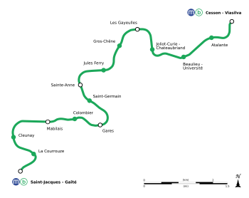
The line runs 13.4 kilometres (8.3 mi) north-east to south-west between Cesson - Viasilva and Saint-Jacques - Gaîté with 15 stations (12 of which underground).
The two terminal stations, Saint-Jacques - Gaîté and Cesson - Viasilva, as well as Les Gayeulles are served by the Parc relais (ride-and-park service) operated by STAR.
At the end of the viaduct on the "Beaulieu - Université" station side, the line goes underground via an opening on the ground next to the parking lots of the university residence.
With the new line about to be open, the operator of Rennes' public transport system, Service des Transports en Commun de l'Agglomération Rennaise (STAR) have announced changes for the bus network,[8] scheduled to take effect on 24 October, a month after the opening of Line B.