Los Flamencos National Reserve
[4] The reserve covers a total area of 740 square kilometres (290 sq mi) in the Central Andean dry puna ecoregion[5] and consists of seven separate sections.
[8] Salar de Tara was formerly filled by an overflowing lake that covered 200 square kilometres (78 sq mi) of area and has left prominent shorelines, 24 of which are recognizable on the eastern side, as well as river deltas.
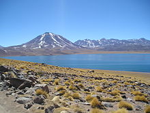
[9] The flora is characterized by the presence of high elevation wetland, as well as yellow straw, broom sedge, tola de agua and tola amaia (two species of Parastrephia), and coirón (Festuca gracillima), which can be observed on flat and hilly terrain and on the slopes of volcanoes and hills Salar de Tara provides a habitat for various rare and endangered species of wildlife.
[11] The flora found here is similar to that found in the Tara and Aguas Calientes areas, characterized by high elevation wetland, yellow straw, broom sedge, tola de agua and tola amaia (two species of Parastrephia), and coirón (Festuca gracillima), which can be observed on flat and hilly terrain.
[15] Located 10 kilometres from the path to Chaxa lagoon, the Quelana section features extensive salt crust and saline mud.
[16] It shares much of the same flora and fauna of the Soncor section, including the three species of flamingos present in Chile as well as eagles, swallows, burrowing owls and geese.
This section includes archaeological sites such as the village of Tulor as well as the Cordillera de la Sal mountain range, which reaches elevations of 2,624 metres (8,609 ft).
The range was formed by the sequential folding of an old salt lake that eventually dried and was forced upwards by the movement of tectonic plates.