Rice Fork
The Rice Fork begins on the upper northwest side of Goat Mountain, on the Colusa-Lake County line, at an elevation of over 6,000 feet (1,800 m).
It quickly descends the steep western slope of the mountain, then bends northward, and flows northwesterly down a narrow winding steep walled canyon for about 18 miles (29 km), crossing two forest roads and adding many tributaries, ending its journey at the southern tip of Lake Pillsbury, at a varied elevation around 1,800 feet (550 m), depending on the lake level.
Before the construction of Scott Dam in the 1920s, which formed Lake Pillsbury, the Rice Fork ran directly into the Eel River.
The Rice Fork drains 33 percent of the total drainage area of Lake Pillsbury, and may contribute a like percentage of the amount of inflow.
Most of the sediment in Lake Pillsbury is deposited in the upper reaches of the Eel River and Rice Fork arms.
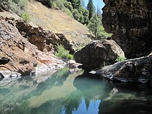
The greywacke has a muddy, brownish-gray sandstone appearance, ranging from rather soft and crumbly in weathered outcrops to solid rocks and boulders in the stream bed of the Rice Fork.
It swiftly descends the steep west slope of the mountain, flowing southwesterly for about 8.1 miles (13.0 km) down a steep canyon, crossing a forest road and passing through Rice Valley, entering Rice Fork on the right about 4.3 miles (6.9 km) upstream from the lake.
Packsaddle Creek begins at about 3,600 feet (1,100 m) on Pine Mountain and flows northeasterly for about 3.1 miles (5.0 km) down a steep canyon, entering Rice Fork on the left near Swallow Rock, at the southern tip of the lake.