Richmond Hill, Ontario
The village of Richmond Hill was incorporated by a bylaw of the York County Council on June 18, 1872,[4] coming into effect January 1, 1873.
Historically the town was bounded along a narrow strip along Yonge Street from Lots 48 to 46 (about Crosby Avenue down to Major Mackenzie Drive), as far east as Church Street and slightly west of Mill Pond (excluding Lot 46 where it ended just north of Arnold Crescent or eastern end of today's Don Head Park).
While Richmond Hill was a prosperous, well developed town, many of the outlying areas annexed were far more rural, with dirt roads, no water mains or sewers and no streetlights, and the time needed to bring municipal services up in these areas, combined with residual unequal tax assessments caused considerable conflict in the municipal politics.
Yonge Street through Richmond Hill expanded from two lanes to four in 1971, relieving congestion on what was known as "Ontario's worst stretch of highway".
[7] The Royal Canadian Air Farce was recorded at the Curtain Club Theatre in Richmond Hill for its first 5 seasons on radio, beginning in 1973.
Mills died in 1980, leaving the company to his son, but the poor economic conditions, combined with increasing property taxes in the growing city made the business unprofitable.
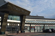
Richmond Hill's growth continued during the 1990s, fuelled in significant part by immigration, with many businesses opened on Highway 7 around Leslie Street serving the new Chinese Community that formed there.
Richmond Hill is the only municipal Canadian government to have light pollution laws in place, due to the presence of the David Dunlap Observatory.
The municipality has a wide purview relating to the interests of the municipality and its residents to develop and maintain policies, practices and procedures through the issuing of bylaws relating to highways, transportation systems apart from highways, waste management, public utilities, culture, parks, recreation and heritage, drainage and flood control, parking, animals, economic development and the licensing of business.
[18] The Richmond Hill Centre for the Performing Arts offers theatre productions, concerts, comedy, and other shows in a multi-purpose space that includes a 631-seat auditorium.
[20] Housed in a restored cottage from the 1840s, the Richmond Hill Heritage Centre offers an exhibit of local history and has a number of educational programs.
[25] In September 2009, Alias Grace Park was opened to honour Margaret Atwood's novel's depiction of the city in Upper Canada prior to John A. Macdonald becoming prime minister.
In the 1990s, Oak Ridges experienced moderate growth, which has spurred environmental action and anti-development movements by numerous organizations.
The community existing prior to the establishment of a post office in 1900 and home to Newton Tannery before 1870 but business dwindled and reverted in the late 20th century as a residential suburb of Richmond Hill.
Headford is now mainly a business park area bounded by Major Mackenzie Drive, Leslie Street, Highway 404 and 16th Avenue.
Beverley Acres is a smaller residential area within Hillsville at southwest corner of Yonge Street and Major Mackenzie Drive.
[57] Richmond Hill's current commercial hub is located near Leslie Street and Highway 7, where it borders Markham's AMD headquarters.
Central Richmond Hill is a very commercial area, housing multiple malls, plazas and entertainment buildings, such as theatres and restaurants.
During the 1990s, Chinese immigrants primarily from Hong Kong moved to Richmond Hill, where they set up businesses and shops catering to the community.
Jefferson includes a large area, roughly bounded by Gamble Road in the south, Bathurst Street in the west and Bayview Avenue in the east.
The ease of accessing the city is threatened by increasing traffic due to growth in the region, as the resulting commutes diminish the usefulness of the road network.
In September 2005, YRT unveiled a new rapid transit initiative entitled VIVA which provides enhanced bus service on major routes using vehicles capable of speeding up traffic lights to lessen the time they idle.
Langstaff Station is near the new Richmond Hill Centre Terminal of York Region Transit at Highway 7 and Yonge Street, and is connected to it by a pedestrian bridge opened in March 2008.
The Richmond Hill Centre Terminal is complete with enclosed heating areas, payphones, and credit card/debit card ticket purchasing machines.
Owing to its proximity to Toronto, there are plans to extend Line 1 Yonge-University of the TTC subway system to the intersection of Yonge and Highway 7.
Thousands of years ago during the last ice-age, glaciers moving in a southerly direction amassed a considerable amount of earth in front of them which they carried forward as they grew.
Gradually, as the temperature increased the growth of the glaciers lessened and eventually they began to recede to what is now the polar ice cap.
The earth that had been collected by the glacier's movement was left in place and the elevated region that remained comprises modern day Richmond Hill.
Kettle lakes are the result of glacier water getting caught in water-tight depressions in the land and are sustained by only rainfall in the immediate area.
The moraine is a further elevated region of loose soil which comprises a significant portion (roughly the northern third) of the land area of the city.