Rill
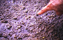
In hillslope geomorphology, a rill is a shallow channel (no more than a few inches/centimeters deep) cut into soil by the erosive action of flowing surface water.
Since soil is regularly left bare during agricultural operations, rills may form on farmland during these vulnerable periods.
Unless soil conservation measures are put into place, rills on regularly eroding areas may eventually develop into larger erosional features such as gullies or even (in semi-arid regions) into badlands.
Rills are created when fire erodes the soil topsoil on hillsides and so are significantly affected by seasonal weather patterns.
Gravity determines the force of the water, which provides the power required to start the erosional environment necessary to create rills.
Some estimates claim rill flow has a carrying capacity of nearly ten times that of non-rill, or interrill, areas.
In 1987, scientist J. Poesen conducted an experiment on the Huldenberg field in Belgium which revealed that during a moderate rainfall, rill erosion removed as much as 200 kg (in submerged weight) of rock.