Rio Monterroso
[2] It remains dry through the average summer weather and flows during the winter rainy season depending on the amount of rain.
The name of the work was "Embovedado del arroyo Monterroso" and the construction company was Construcciones Civiles, S.
[14] In 2017, the plans to build the river park lacked authorization and were never instated; however, a beautification project was conducted.
[20] The third version of the Arroyo de Juan Benítez is located on the eastern wall of the Monterroso culvert, flowing directly under the Calle Parque central.
[citation needed] This is one of 3 versions of outfalls located on the eastern wall of the Monterroso culvert.
Its mouth consists of a five foot tall rectangular concrete outfall, with ceilings that slope up to 6' 5" inside and slant to the right.
This shape is prevalent in many subsurface canals and larger drainage systems using overhead vertical beams and is known as a transition structure to maximise hydraulic efficiency.
Whilst heavy storms and flooding occurred during an news interview with the mayor of Estepona, it was said that the Arroyo De Juan Benítez Embovedamiento project was very important and the new embovedado would be completed if they managed to get enough concentrated personnel.
The original N340 route of the Estepona crossing followed the old horseshoe path, which ran between the coast and the seafront of the town after passing a small fishermen's neighborhood and the Monterroso River.
The growth of the town was, in any case, extremely slow, and in the mid-sixties the crossing continued to be limited to the historic center and the fishermen's neighborhood.
It was not, in fact, until the last years of that decade when the construction of a first round was proposed and, with the inclusion of the route from Malaga to La Línea and Cádiz in the program of the Network of Asphalt Itineraries (REDIA, 1967/1971), the transformation of the crossing into a continuous axis of four lanes of 3.50 meters.
Although growth in the road environment remained weak, transit traffic observed strong increases throughout the decades of the seventies and eighties, turning the crossing into a highly conflictive artery that, in addition, generated a strong barrier effect between the town and the beach.
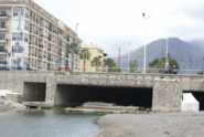
[26] In April 1965, the Monterroso River was originally culverted on the coastline and extended was approximately 45 metres (148 ft) long for use as the n340 passover.
[citation needed] The majority of drainage lines that both systems, Monterroso and Juan Benítez intercept are runoff from the city of Estepona above, a portion of these are lateral lines that directly connect to catch basins, others involved are storm drainage networks that discharge into the underground system.