Rio Negro (Amazon)
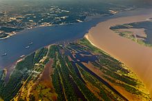
Despite its high flow, the Rio Negro has a low sediment load (5.76 million tonnes per year on average in Manaus).
[9] The young river generally flows in an east-northeasterly direction through the Puinawai National Reserve, passing several small indigenous settlements on its way, such as Cuarinuma, Brujas, Santa Rosa and Tabaquén.
After roughly 400 km (250 mi) the river starts forming the border between Colombia's Department of Guainía and Venezuela's Amazonas State.
After forming the border between Colombia and Venezuela for 260 km (160 mi) the Rio Negro reaches the Piedra del Cocuy, an igneous rock formation from the Precambrian era, belonging to the Guyana Shield.
After several more rapids and imposing views of the Adormecida mountain chain the river leaves the Guyana shield it traversed in its upper and middle course.
During this season, from April until October, it is a succession of lagoons, full of long islands and intricate channels with a lot of water wildlife.
[19] During a 1924–25 expedition, Alexander H. Rice Jr. of Harvard University traveled up the Orinoco, traversed the Casiquiare canal, and descended the Rio Negro to the Amazon at Manaus.
The older idea that these are "hunger rivers" is giving way, with new research, to the recognition that the Rio Negro, for example, supports a large fishing industry and has numerous turtle beaches.
If explorers did not find many Indigenous peoples along the Rio Negro during the 17th century, it is likely that their populations were reduced because of new infectious diseases and warfare rather than low river productivity.