River Camel
[2] The River Camel rises on Hendraburnick Down (UK Grid Reference SX135875) on the edge of Bodmin Moor, an area which forms part of the granite spine of Cornwall.
[27] The Camel's catchment area covers 413 km2[26] on the western side of Bodmin Moor, and is mainly Devonian slates and granite,[28] with some shales and sandstones.
[29] Today the tidal parts of the River Camel are subject to flood risk, especially during spring tides after periods of high rainfall when the catchment is already saturated.
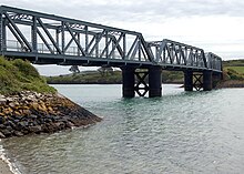
On the west bank, the Camel Trail crosses the triple-span “Iron Bridge” over Little Petherick Creek then passes below Dennis Hill and its obelisk.
The fishing port of Padstow stands on the west bank from where the Black Tor Ferry (officially owned by the Duchy of Cornwall) carries people across the river to Rock.
In the past there was a proposal to build a pier on the doom bar to funnel the tide and thus scour the main channel and keep it navigable, but nothing was ever constructed.
[41] A legend as to how the Doom Bar came about describes how a local fisherman is reputed to have shot a mermaid with an arrow, with the result that she cursed Padstow by putting the sandbar between the harbour and the sea.
The river then flows past Trebetherick Point and swings east over a rocky stretch of foreshore punctuated by sand at Greenaway before reaching the beach at Polzeath, a location for surfing.
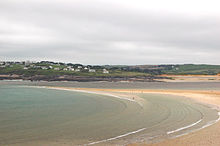
[48][49] Sea fishing for Flounder is also a feature of the River Camel, particularly in the sandy parts between Padstow and Cant Hill[50] On the western bank Hawker's Cove, Tregirls beach and St Georges Cove lie between Stepper Point and Padstow, while on the eastern bank moving upstream from Pentire Point is Polzeath beach, Daymer Bay and Rock.
This route is a very ancient one used by travellers from Ireland and Wales making for Brittany and wishing to avoid the dangerous seas around Lands End.
[58] Water skiing takes place on the estuary based in Rock, with four set courses located between Dennis cove and Pinkson creek.
[62][63][64] The majority of the Camel Estuary, from Padstow/Porthilly upstream to Wadebridge are part of the Cornwall Area of Outstanding Natural Beauty[65] and thus considered worthy of special landscape protection.
Hawke's Wood reserve, owned by the Cornwall Wildlife Trust, is on the south side of the Camel Valley between Wadebridge and Dunmere.
Here is an abandoned quarry in a mature woodland of predominantly sessile oak,[71] this latter habitat also being named as contributary to the Special Area of Conservation listing.
Large flocks of waders can be seen in winter, preyed on by peregrine falcons, and a migrant osprey often pauses a few days to fish in spring and autumn.
[73] Upstream and on several of its tributaries, kingfishers can be seen,[72] while the Cornwall Wildlife Trust reserve at Hawkes Wood is noted for nuthatches and tawny owls.
Tregunna Hide (Grid reference SW 969 738), owned by Cornwall County Council, is located by the Camel Trail[75] and is open to the public.
Burniere Hide (Grid Reference SW 982 740) is owned by the Cornwall Birdwatching and Preservation Society (CBWPS)[75] is open to members.
Flounders can be found in the brackish waters around the entrance to Little Petherick Creek,[50] and Daymer Bay is noted as a location for fishing from the rocks.
[79] Egg cases from shark and ray species are regularly found on the beaches near the mouth of the river, and have been recorded as far up as Porthilly and Dennis Cove.
[84] The largest and most unusual fish reported to have been found in the river was a sturgeon weighing 432 pounds (196 kg) which was stranded by the outgoing tide in June 1887.
[85] By the Atlantic Ocean the flora is distinctly maritime, characterised by thrift and sea campion on exposed clifftops and spring squill and heather in the turf.
Stunted blackthorn and gorse tolerate more exposed sites, while the quarry on Stepper Point is home to many species of marsh plants.
The cull, which resulted in over 1500 badgers being killed in North Cornwall in 2016,[102] is intended to reduce instances of Bovine TB but has proved controversial.
[114][115] Soon after in 1796 an act of Parliament was passed authorising a canal from Guineaport to Dunmere with a branch to Ruthernbridge but in the event no start was made and the scheme lapsed.
[114] With boats as one of the main methods of transporting goods until the advent of the railways there were several quays along the river, often at the limit of navigation of the many tributaries and creeks on the estuary.
Despite the many opportunities for transport along the estuary, historically the main traffic on the river above Padstow was to the Quays at Wadebridge where there is evidence of a dock dating back as far as Elizabethan times, and in 1830 the limit of navigation was recorded as Guineaport.
[145] The routes of the three main roads through Cornwall, following generally the alignment of the current A30, A38 and A39 are believed to have ancient origins, and if this is true then there would need to be a historic crossing of the Camel, most likely somewhere near Wadebridge.
[160][161][162] While the heritage value of ancient crossings is great, continued use of structures that are several hundred years old and that were designed and built with lighter and less frequest traffic in mind can have a deleterious effect on the fabric of these bridges.
An inquiry into the incident (the worst of its kind in British history) started in 2002, and a report was issued in January 2005 but questions remain as to the long-term effects on the health of residents.