River Ryton
It rises close to the Chesterfield Canal near Kiveton Park, and is joined by a series of tributaries near Lindrick Common in the Metropolitan Borough of Rotherham, South Yorkshire, England.
It supplies water to the Chesterfield Canal through two feeders, and a number of the bridges which cross it are of interest architecturally, which has resulted in them becoming Listed structures.
The region through which the river flows is underlaid by an extensive water-bearing porous rock structure called the Magnesian Limestone aquifer, which is near the surface in the west and dips downwards to the east.
The Triassic Sherwood Sandstone aquifer is another porous rock layer which covers this to the east, and is the major geological component of the area.
This is affected by the extraction of groundwater, particularly for public water supply, and by fracturing of the aquifers as a result of subsidence caused by deep coal mining.
[3] The catchment area above the Worksop gauging station is 29.7 square miles (77 km2) and the mean flow is 8.55 million gallons (38.88 Megalitres) per day.
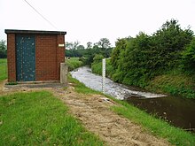
Shortly afterwards, the Brancliffe feeder leaves the river, following an S-shaped course to supply water to the Chesterfield Canal near Turner Wood locks.
All had ceased to operate by 1826, but a new water mill had been constructed further to the west, near to the present junction of Newcastle Avenue and the A57 Worksop bypass.
More exotic activity recorded includes demonstrations of the launching of a lifeboat, and the bathing of elephants when travelling circuses visited the town.
This section counts as a confined space, and was surveyed in 2007, in a joint venture between the Environment Agency, a team of divers, and Bassetlaw District Council.
Priory Water Mill was in use from the medieval period until 1876, and a large lake called the Canch was formed in 1820, by constructing a dam across the leat which fed it.
[10] The buildings were utilised by William Bramer and Sons for their business of making chairs until they burnt down in 1912,[12] and the site has more recently become the location of a sensory garden.
The river then follows a winding course through the estate of Osberton Hall and the village of Scofton, turning north to skirt the western edge of Ranby.
Ranby Chequer Bridge marks the point at which the river, having flowed eastwards for most of its course, turns to the north west.
The Environment Agency used a six-stage rating scale, from 'A' to 'F', called the General Quality Assessment, to classify rivers.
The reasons for the ecological quality being less than good include the discharge of effluent from sewage treatment works, and drainage from the transport infrastructure.
Like most rivers in the UK, the chemical status changed from good to fail in 2019, due to the presence of polybrominated diphenyl ethers (PBDE), perfluorooctane sulphonate (PFOS) and mercury compounds, none of which had previously been included in the assessment.
A number of small streams contribute to the improvement of water quality, so that wild brown trout thrive as far as Worksop.
Nevertheless, the lower reaches are still used for organised angling, and are the only part of the River Idle system where this activity takes place.