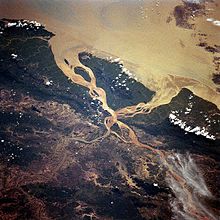
River bifurcation
If the streams eventually merge again or empty into the same body of water, then the bifurcation forms a river island.
A location where a river divides around a rock fin, e.g. a volcanically formed dike, or a mountain, may be more lasting as a result of higher material strength and resistance to weathering and erosion.
[3] In deltas, the directions of distributaries resulting from bifurcation are easily changeable by processes like aggradation, or differential subsidence and compaction.
Rivers are abundantly used as political boundaries, marking borders between regions of opposing countries, states and peoples, among other things.
[3] Bifurcated rivers are largely semi-permanent, and are subject to constant change in their configuration from evolving terranes and flow rates.
[6] The water level differences in braided systems are themselves caused by closure of branch entrances as a result of bar growth.
River bifurcations impact the surrounding area in a plethora of ways, namely, redistributing flow of water, sediment and nutrients throughout a watershed and delta.
Bifurcations are a major distributor of nutrients and mineral particulates to biologically rich areas in deltas.
Sudden deterioration or initiation of bifurcated systems can disrupt the deposition of material required for various organisms to live, and thus has an indirect impact on surrounding ecosystems via flow patterns.