Riverside County, California
Roughly rectangular, Riverside County covers 7,208 square miles (18,670 km2) in Southern California, spanning from the greater Los Angeles area to the Arizona border.
Between 2007 and 2011, large numbers of Los Angeles-area workers moved to the county to take advantage of more affordable housing.
In addition, smaller, but significant, numbers of people have been moving into southwest Riverside County from the San Diego metropolitan area.
[10][11] The Indigenous peoples of the valleys, mountains and deserts of what is now Riverside County are the Serrano, the Payómkawichum, the Mohave, the Cupeno, the Chemehuevi, the Cahuilla, and the Tongva.
[12][13] The Aguanga and Temecula Basins, Elsinore Trough and eastern Santa Ana Mountains are the traditional homelands of the Payómkawichum.
The inland valleys in the Santa Rosa and San Jacinto Mountains and the desert of the Salton Sink are the traditional homelands of the Cahuilla.
The first European settlement in the county was a Mission San Luis Rey de Francia estancia or farm at the Luiseño village of Temescal.
The ranch was to be one of the Mission's principal rancherias, and the most distant, and it occupied most of today's San Gorgonio Pass area.
New Mexican colonists founded the town of La Placita on the east side of the Santa Ana River at the northern extremity of what is now the city of Riverside in 1843.
None of the proposals were adopted until a measure to create Riverside County was signed by Governor Henry H. Markham on March 11, 1893.
Riverside County was officially formed on May 9, 1893, when the Board of Commissioners filed the final canvass of the votes.
[16] Riverside county was a major focal point of the Civil Rights Movements in the US, especially the African-American sections of Riverside and heavily Mexican-American communities of the Coachella Valley visited by Cesar Chavez of the farm labor union struggle.
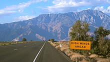
There are probably at least three geomorphic provinces: the Inland Empire western portion, the Santa Rosa Mountains communities such as Reinhardt Canyon, and the desert region.
The California endemic Blue oak, Quercus douglasii is at the southernmost part of its range in Riverside County.
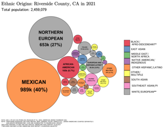
The racial makeup of Riverside County was 1,335,147 (61.0%) White (40.7% Non-Hispanic White), 140,543 (6.4%) African American, 23,710 (1.1%) Native American, 130,468 (6.0%) Asian (2.3% Filipino, 0.8% Chinese, 0.7% Vietnamese, 0.6% Korean, 0.5% Indian, 0.2% Japanese, 0.1% Cambodian, 0.1% Laotian, 0.1% Pakistani), 6,874 (0.3%) Pacific Islander, 448,235 (20.5%) from other races, and 104,664 (4.8%) from two or more races.
There were 995,257 residents of Hispanic or Latino ancestry, of any race (45.5%); 39.5% of Riverside County was of Mexican origin, 0.8% Salvadoran, 0.7% Honduran, 0.6% Puerto Rican, 0.3% Cuban, and 0.2% Nicaraguan descent.
It provides patrol, detective, and other police services for the unincorporated areas of the county plus by contract to the cities and towns of Coachella, Eastvale, Indian Wells, Jurupa Valley, La Quinta, Lake Elsinore, Moreno Valley, Norco, Palm Desert, Perris, Rancho Mirage, San Jacinto, Temecula and Wildomar.
In 1932, it was one of only two counties in the entire West Coast to vote for Republican president Herbert Hoover over Roosevelt during the latter's landslide victory.
[citation needed] The following table includes the number of incidents reported and the rate per 1,000 persons for each type of offense.
Metrolink trains serve nine stations in Riverside County: Riverside–Downtown, Riverside–La Sierra, Corona–North Main, Corona–West, Jurupa Valley/Pedley, Riverside–Hunter Park/UCR, Moreno Valley/March Field, Perris–Downtown, and Perris–South.
[80] These trains provide service to Orange, San Bernardino and Los Angeles counties seven days a week, with a primarily commuter-oriented schedule.