Riviera Maya
It straddles the coastal Federal Highway 307, along the Caribbean coastline of the state of Quintana Roo, located in the eastern portion of the Yucatán Peninsula.
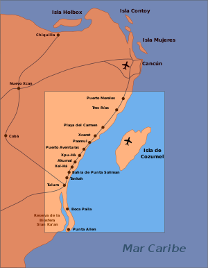
The Riviera Maya includes the municipalities of Solidaridad in the north and Tulum in the south, and extends approximately 40 km (25 mi) inland, to the border with the state of Yucatán.
The Riviera Maya is famous for its large scale all-inclusive resorts and a historical tourism base of smaller boutique hotels as well as the many fine-dining restaurants available along the Fed 307 and on or near the beaches.
As is common in karst, underground river networks have formed by dissolution, and these have been explored and mapped by cave diving through sinkhole collapses, locally called cenotes.
The whole of the Yucatán Peninsula is underlain by a density-stratified coastal aquifer system with a lens-shaped freshwater body floating on top of intruding saline water.
These groundwater resources, accessed via the thousands of cenotes throughout the landscape, once supported the Maya civilizations and today remain the only natural sources of potable water in the area.
The Caribbean coastline is a series of crescent shaped white sand beaches interrupted every 1–10 km by rocky headlands and inlets, called caletas, through which groundwater discharges into the coastal water.
Most tourists to the Riviera Maya arrive through Cancún International Airport, approximately 50 km (31 mi) north of Playa del Carmen.