Roads in Puerto Rico
Puerto Rico has approximately 14,400 kilometers (8,900 mi)[1] of national, forest and municipal roads.
The National Highway System roads are maintained by the Puerto Rico Department of Transportation and Public Works (Spanish: Departamento de Transportación y Obras Públicas, or DTOP).
At one time, Puerto Rico was treated as a state for the remittance of federal-aid highway funds, but with TEA-21, a legislative act, "Puerto Rico no longer receives a share of the apportioned Federal-aid highway funds.
These are within the El Yunque National Rain Forest, near Río Grande, Puerto Rico.
By the 16th century there was a rough road called Camino de Puerto Rico connecting San Germán (which was located near the mouth of the Añasco River) to other areas of Puerto Rico, including San Sebastián, Arecibo, Toa Alta, and Caparra.
[7] The first highways of Puerto Rico were paved with macadam, a layer of crushed rock and cement.
They called Puerto Rico's Carretera Central "the finest road in the Western Hemisphere.
[10] In 1905, the United States, suspended the system, and once the Camineros Peatones were no longer doing a daily visual inspection, the highways quickly deteriorated.
[11] Puerto Rico Highway System roads, regardless of their network classification, are maintained by the centralized, commonwealth-level, Puerto Rico Department of Transportation and Public Works, known in Spanish as the Departamento de Transportación y Obras Públicas or DTOP.
[19][20] In 2009, primary routes were about 14% of the total Puerto Rico Highway system mileage, secondary were about 30%, and tertiary about 56%.
[22] A primary road's purpose is to facilitate movement of passengers and freight between major regions of the island.
This is due to the fact that the original PR-2 went through every town center but these sections were bypassed and designated R to alleviate congestion.
[24] Secondary roads are numbered in the 100 to 299 range and generally follow a grid pattern.
PR-100 is located in the southwestern town of Cabo Rojo, while PR-198 is in Juncos, Las Piedras and Humacao in the eastern part of Puerto Rico.
As of February 2014, the highest secondary highway number assigned was 252 (PR-252), located in the northeastern municipality-island of Culebra.
[23] Tertiary highways or roads provide access to a municipality's main urban area from peripheral communities.
This changes in the region to the east of San Juan as both northern and southern areas are covered by roads of the 900-999 grid.
They are often dead end branches, and are common in the mountain regions of the main island.
Residents of Puerto Rico pay federal fuel and tire taxes.
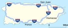
They run along various combinations of Puerto Rico highways and do not follow the even-and-odd-number rule used in the mainland United States.
Puerto Rico is exempt from following certain specifications for its Interstate Highway System.
As written under the section road maintenance, at times the state government has entered into a Memorandum of Agreement with municipal governments for the upkeep of a state tertiary roadway (note this is a state-owned road that runs entirely within a single municipality), but this does not make it a municipal road—the road continues to maintain its state signage and ownership.