Rock of Solutré
In the Cenozoic era, eastern Burgundy underwent the effects of the alpine rising; while the Alps grew higher, the Saône basin sank.
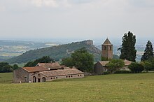
The surrounding landscape eroded to rounded hills, leaving the cliffs of Soulutré and Vergisson as monadnocks on the west side that contrast with gentle slopes on the east.
The Saône plain extends to the east, with a view of Mâconnais in the foreground, then Ain and Dombes against the backdrop of the Alps and Mont Blanc in good visibility.
In the three other directions the countryside is less open and bounded by the lines and crests of surrounding hills, with vineyards, villages, and typical Mâconnais settlements, in particular: Solutré's remains from prehistoric times are some of the richest in Europe in bones and stone artifacts.
In the homes, numerous flint tools were found, including spear-points, choppers and other scrapers, and also a large hoard of bones, mainly from reindeer, but also from horses, mammoths, wolves, and cave lions.
Testot-Ferry and Adrien Arcelin decided to see if they could determine scientifically how large the deposit was that they had brought to light, and to examine with great care the remains that they had recovered.
Providing shelter and food for migrant groups, the foot of the rock, strewn with debris, afforded hunters the opportunity to develop traps.
This theory, which was never brought by Testot-Ferry, in his scientific publications, in fact appeared in Arcelin's prehistory-based novel, "Solutré" (Paris 1872); it has never been other than a fiction which caught the popular imagination.
After the truce signed in Mâcon on 4 December 1434 accepting the Burgundian presence in Mâconnais, this castle, the only remaining high place in the region not reduced by the Duke of Burgundy, was handed over to him.
A high place for the French Resistance during World War II, the rock was ritually climbed each year by President François Mitterrand and certain of his friends.
From the deforestation of the original Gaulish forest to the plantation of the first vineyards, to contemporary polyculture and current monoculture of wine production, the countryside has been shaped and changed.
This pasturing as well as the practice of burning maintained the dry grass which had developed, hosting numerous rare or protected plant and animal species, who found their most northerly home.
Notable birds of the rock include the ortolan bunting, the scops-owl, the European nightjar, the short-toed snake eagle, the northern harrier and the woodlark.
The area's predilection for Chardonnay has given rise to wines with international reputations:[1] The Rock had been partially protected by the law of 2 May 1930 on the protection of natural monuments and sites of artistic, historic, legendary or picturesque character, by virtue of its spectacular aspect and the archeological sites which it sheltered, and was part of the Natura 2000 network in the context of its pelouses calcioles grassland.
This law does not add any regulatory constraints but constitutes a tool for restoring and bringing value to the site, setting up a reception, and generating a dynamic local economy and a continuing management of the area.
The pathways have been revised to enhance safety for visitors and to stop the degradation of tracks, the parking lot has made way for a new one, which integrates almost completely with the landscape.