Rollins Pass
The abandoned rail route over Rollins Pass was nominated for and accepted into the National Register of Historic Places in 1980 because of significant events and engineering feats accomplished by railroading efforts in the early 20th century.
[22] The elevation of '11,660 feet' commonly attributed to Rollins Pass (note the McClure sketch later in this article) "reflects what might have been an original survey value obtained during either the late wagon road era or early railroad construction.
[25] Paleoindians and early Native Americans were the first to utilize Rollins Pass as a natural, low crossing over the Continental Divide for the purposes of communal hunting of large game, including bighorn sheep and elk.
[2]: 9 [88][89][90] The line included a 23-mile (37 km) stretch over the top of the Continental Divide, at Rollins Pass, with a two to four percent grade and switchbacks along many sections; the result was one of the highest adhesion (non-cog) standard-gauge railroads ever constructed in North America.
[96] In summers, the train ride from Denver to Corona was advertised as a trip, "from sultry heat to Colorado's north pole;" tourists could stand in snowdrifts in the middle of July or August.
[97][98][99][100][101][102] Tours launched from the Moffat Depot,[103] a small building constructed in the Georgian Revival style, featuring two-story tall windows, intricate exterior brickwork, and roofline pommels.
[104] This building, located several city blocks northwest from Denver Union Station, was added to the National Register of Historic Places in 1976,[105] and lay dormant for many decades after it was shuttered in 1947;[106] in 2015, it was made the focal point of a senior living community center, after it was meticulously restored.
[24][110][111] Workers on the Moffat Road had an adage: "There's winter and then there's August",[24] reflecting the fact that in the high mountains of Colorado, snow will often cover the area for more than six months and very cold and snowy weather may occur nearly year-round.
It was these heavy snowstorms that led to the financial demise of the Moffat Road and served as the incentive for construction of a permanent railroad tunnel through the Rocky Mountains and into Middle Park.
[2] However, many derailments, wrecks of Mallet locomotives, accidents resulting in injury and/or death,[112][113][114] and/or the loss of portions of rail manifests occurred on both sides of the pass:[95] Despite the challenges documented above, by 1918, it was reported that 45 or 46 engines were part of the motive power of the railroad along with 3 rotary snowplows.
This emergency route was needed only once[193] for a several day-long closure: on Thursday, July 25, 1929, dry rot of wooden timbers caused a collapse and 75 feet (23 m) of rock caved-in and blocked the Moffat Tunnel near the East Portal.
[206] Several years later, on Saturday, September 1, 1956, Colorado lieutenant governor, Steve McNichols, opened Rollins Pass as a non-vital and seasonal recreational road.
In 1989, after several engineering studies and structural strengthening of Needle's Eye Tunnel were accomplished, the complete road was re-opened only to close permanently in 1990, due to a rockfall injuring a sightseer.
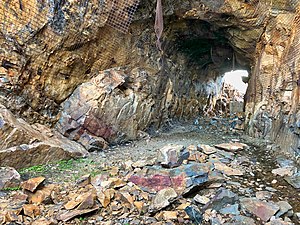
[216] The Archaeological Resources Protection Act along with the Antiquities Act, among other federal and cultural laws, recognizes the nonrenewable and vulnerable nature of cultural resources[217] and these laws protect and make it illegal to collect artifacts, including but not limited to: arrowheads, horseshoes, buttons, cans, glass or ceramic bottles, dishware and utensils, coal, railroad spikes, snowshed wood, railroad ties, and telegraph poles from Rollins Pass.
[2]: 12 The material record of Rollins Pass is illegally carried away each year—some by poachers[220]—others in the backpacks of well-intentioned visitors who want a souvenir; but once artifacts are removed, a place can never again reveal the mysteries of the past.
[216] Visitors are encouraged to preserve the area for future generations by leaving items in place and sharing photographs and GPS coordinates (if available) with researchers dedicated to telling the story of Rollins Pass and an internet resource has been set up to aid with this project.
[224] There are several ghost towns on or near Rollins Pass, the most notable being Arrow, Corona, Ladora, the East Portal construction camp, Mammoth, and Tolland.
[232][2]: 125 Rollins Pass consists of several distinct floral environments including lodgepole pine and quaking aspen at lower elevations, and krummholz at tree line.
[2]: 65 [243] A summer 2006 project led by the United States Forest Service and having the participation of both environmental and user groups saw improvements made to wetlands, lakeshore, and upland habitats at Yankee Doodle Lake and Jenny Creek.
Typically, these protective restrictions tend to be enacted starting as early as mid-late July or later in August: Arctic conditions are prevalent during the winter, with sudden blizzards, high winds, and deep snowpack.
Historically, newspaper reports wrote of both visitors and railroad workers experiencing heart attacks and pneumonia at the summit of Rollins Pass as well as severe frostbite, including in July.
From the accident report, "The avalanche released from a southeast-facing slope and fell 600 vertical feet [180 m] and stopped by crashing through the 10-inch [25 cm] thick ice of Yankee Doodle Lake.
[304][305] Rollins Pass is managed by the United States Forest Service[307] as a recreational location and can be accessed from roads on both west and east sides; however, no motorized route connects across the Continental Divide.
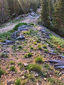
[318][319] A series of hand-constructed stone windbreaks exist above timberline north of Needle's Eye Tunnel—these structures date to the railroad era on Rollins Pass and are not prehistoric.
"[325] The first high-country snowstorms bring fierce winds and create impassible snow drifts that are not plowed; this effectively puts higher landmarks—including the summit—out of reach as soon as late September or early October.
The road up the pass on the eastern side from the Peak to Peak Highway (State Highway 119) begins at the East Portal road running west, parallel to South Boulder Creek and the current Union Pacific Railroad tracks, to the East Portal of the Moffat Tunnel, and then rises on the abandoned railroad grade from Giant's Ladder to the closed Needle's Eye Tunnel.
[340] Shortly before the Spruce Wye, the land ownership transitions back to the Arapaho and Roosevelt National Forest where it remains uninterrupted up to and including the summit and surrounding areas.
[341][342] Shortly after the ghost town of Arrow and several miles before the Ranch Creek Wye, the land ownership transitions back to the Arapaho and Roosevelt National Forest where it remains uninterrupted up to and including the summit and surrounding areas.
Of late, one attempt at a land exchange with the US Forest Service would have transformed the entrance of the western portion of Rollins Pass into an opening, quite literally, for a private development.
[437][438] The glass-domed lighted beacon rotated six times per minute, marking the airway between Los Angeles and Denver, and it held a two-million candlepower electric lamp with a 24-inch (610 mm) parabolic reflector.


!["Snow cuts on Rollin's [sic] Pass, Moffat Road, Colo." This is a colorized sketch of McClure photograph 257-8067, the description stating, "Snow scene, summit Rollin's Pass: elevation, 11,660 feet; on Moffat Line R. R., three hours' ride from Denver. Photograph taken in May, 1906. The region of perpetual snow. Photograph by L.C. McClure, Denver."](http://upload.wikimedia.org/wikipedia/commons/thumb/b/b0/Rollins_Pass_Snow_Cuts_Moffat_Road_circa_1910s.JPG/300px-Rollins_Pass_Snow_Cuts_Moffat_Road_circa_1910s.JPG)
![The winding inefficiency of the outdoor Rollins Pass rail route is brought into sharp contrast when compared with the direct, weather-agnostic Moffat Tunnel route. The Moffat Tunnel eliminated 10,800 degrees of curvature along the Rollins Pass route.[186]](http://upload.wikimedia.org/wikipedia/commons/thumb/c/c5/Moffat_tunnel_rollins_pass.png/300px-Moffat_tunnel_rollins_pass.png)
![Illegal off-roading of a vehicle on Rollins Pass near Mount Epworth and Deadman's Lake. The alpine tundra is extremely fragile and can take 100–500 years to fully recover.[229][230]](http://upload.wikimedia.org/wikipedia/commons/thumb/6/6e/Vehicle_on_Alpine_Tundra_on_Rollins_Pass.jpg/300px-Vehicle_on_Alpine_Tundra_on_Rollins_Pass.jpg)


![A vehicle has not followed the published Motor Vehicle Use Maps (MVUMs) and has parked inside of the Indian Peaks Wilderness area, where motorized vehicles are prohibited. Fines can be as much as $5,000.[306]](http://upload.wikimedia.org/wikipedia/commons/thumb/e/e4/Truck_Parked_Inside_Indian_Peaks_Wilderness.jpg/300px-Truck_Parked_Inside_Indian_Peaks_Wilderness.jpg)