Saddle (landform)
[citation needed] A saddle is the lowest area between two highlands (prominences or peaks) which has two wings which span the divide (the line between the two prominences) by crossing the divide at an angle, and, so is concurrently the local highpoint of the land surface which falls off in the lower direction.
That is, the drainage divide is a ridge along the high point of the saddle, as well as between the two peaks and so defines the major reference axis.
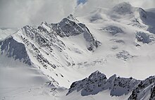
A saddle can vary from a sharp, narrow gap to a broad, comfortable, sway-backed, shallow valley so long as it is both the high point in the sloping faces which descends to lower elevations and the low area between the two (or three or four.
A col is sometimes defined as the lowest point on a saddle co-linear with the drainage divide that connects the peaks.
[2] Monkhouse describes a saddle as a "broad, flat col in a ridge between two mountain summits.
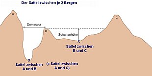
• There are three peaks ( Schartenhöhe ) or prominences shown labeled 'A', 'B', & 'C' .
• The diagram illustrates the topographic isolation (German: Dominanz )- the distance from a prominence which is also a minimum to the point of the same height .
• The 'isolation' (German: Dominanz ) of the right two peaks is not labeled, but is represented by the dashed line.
• "sattel zwischen" means saddle between , so the labeling is saying the saddle between A and C is the same saddle as between A and B