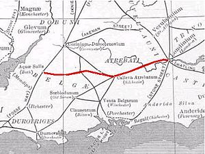
Roman road from Silchester to Bath
The Roman road from Silchester to Bath connected Calleva Atrebatum (Silchester) with Aquae Sulis (Bath) via Spinae (Speen), Cunetio (near Marlborough) and Verlucio (near Sandy Lane).
[1] The road was a significant route for east–west travel and military logistics in south-east England during the 1st to 5th centuries.
[2] During the Middle Ages, the road was used by drovers, as well as by merchants and travellers.
[3] Portions of the Roman road are extant, while in other places all apparent vestiges are absent from view.
In the early 19th century, Colt-Hoare surveyed and mapped its course from Overton Down (west of Marlborough) to Bath; the rest was only known in isolated sections until a study by Hugh Toller was published in 2013.