Roraima
[6] It is bordered by the state of Pará to the southeast, Amazonas to the south and west, Venezuela to the north and northwest, and Guyana to the east.
[11] The history of Roraima is strongly linked to the Branco River, which allowed the first Portuguese settlers to arrive in the region.
The Branco River Valley's strategic position made it coveted by the English and the Dutch, who entered Brazil through the Guiana Shield in search of indigenous people to be enslaved.
The Portuguese settlers defeated and expelled all invaders, establishing Portugal's sovereignty over the region of Roraima and part of the Amazonas.
The first meaning comes from the windy climate in the region, where indigenous people believed that the winds that blew through southern Venezuela came from that place.
Before the arrival of the Portuguese, the English and the Dutch were already attracted to the region, to explore the Branco River Valley through the Guyanas.
For this, they organized rescue troops (purchase of indigenous people transformed into slaves during wars of opposing ethnic groups), war troops (punishment and enslavement of indigenous people who attacked Portuguese nuclei or prevented evangelization) and the search for Brazilian products for sale, the so-called sertão drugs.
[20] The demarcations foresaw by the Treaty of Madrid, of 1750, also lead to a great extent: with the creation of a new administrative unit in the region, the intention was to implement, in practice, the colonization of the Upper Negro River, creating the necessary infrastructure for the meeting and the work of the Portuguese and Spanish demarcation committees, and this meeting never took place, having Portuguese moulds temporarily occupied the course of the lower Branco River in the meantime, carrying out plantations of manioc and other food, for the provisioning of the commission.
The Fort, which no longer exists today, had the main purpose of providing the Portuguese with total sovereignty of Portugal over the lands of the Branco River Valley, which aroused international greed due to its little exploitation.
[18] The Portuguese colonizers, after assuming sovereignty and total control of the region, created several villages and towns in the locality, together with indigenous natives.
[18] To guarantee the presence of the Portuguese settlers in the lands of the Branco River Valley, commander Manuel da Gama Lôbo d'Almada started breeding cattle and horses in the territory, in 1789.
However, the state's population only found stability after its emancipation, a century later, with the gold and diamond mines that attracted migratory waves from different regions of the country.
[22] Because of its variations, the relief is divided into five degrees: The first-degree houses areas of the state that can be flooded, which do not have a specific form of relief, but which are covered by a thin layer of water; the second degree would be the Branco River pediplain, an important unit of enormous expression in the state since it occupies a large part of its lands.
Its territory is abundantly irrigated by 14 rivers, being these: Água Boa do Univiní, Ailã, Ajarani, Alalaú, Branco, Catrimani, Cauamé, Itapará, Mucajaí, Surumu, Takutu, Uraricoera, Urubu and Xeruini.
[30] In the Roraiman Amazon rainforest region, animals such as jaguars, tapirs, peccaries, alligators, margay cats, otters, deers, monkeys, and other species are found.
Among the main fish are the pacu, peacock bass, surubi, matrinxã, redtail catfish, tambaqui, acará, mandi, cachorra, piranha, traíra, piraíba, arowana and many other species.
Five municipalities – Boa Vista, Rorainópolis, Alto Alegre, Caracaraí and Bonfim – concentrate more than half of the population of Roraima.
[41] In its historical formation, the Roraiman demography is the result of the miscegenation of the three basic ethnic groups that make up the population in the state: the Indigenous, the Europeans and the Africans, thus forming the mestizos of the region (caboclos).
Later, with the arrival of migrants, especially from the Northeast of Brazil,[42] a "broth" of singular culture was formed, which characterizes a large part of the population, its values and way of life.
It belongs to the Ecclesiastical Province of Manaus and the Northern Regional Episcopal Council of the National Conference of Bishops of Brazil.
[55] A survey carried out by Portal G1 identified Roraima as one of the Brazilian states that best remunerates middle school teachers, with an average salary of R$ 2,099.47 for 25 hours per week.
It is said that the state works in the so-called "paycheck economy", when there is a circulation mainly of the amounts paid in salaries to public servants and private employees of commerce.
This form of supply ended due to two main factors: population growth in the state, through the inauguration of the Manaus–Boa Vista Road, and the decrease in the cattle herd.
The biggest problems of this crop are in the area of guaranteeing land tenure, its incompatibilities with environmental laws, in addition to irregularity and poor reliability of transport.
These two largest crops in Roraima decreased with the conquest by the peoples from the Demarcation of the Raposa Serra do Sol Indigenous Area.
[62][63] Roraima has always occupied a secondary position in the economic geography of the Amazon when it comes to plant extractivism, producing Brazil nuts, rowanberries and wood.
The commercial sector is traditional, buying from other places, such as São Paulo and Manaus, and reselling in Boa Vista and other municipalities.
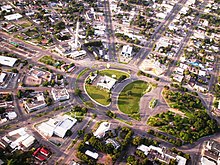
[69] The most populous of them is Boa Vista, with 419,652 inhabitants,[39] being the oldest municipality in the state, emerged as a village, the first with urban characteristics in Roraima.
[6][76] There is also the BR-210, also called Perimetral Norte, a project originating in the mid-twentieth century, from the Federal Government, which had been carried out only partially and which, in principle, would link the state to Pará, Amapá and the municipality of São Gabriel da Cachoeira (in Amazonas).
In it, there are inscriptions of ancient civilizations, such as rock paintings, pieces of ceramics, hatchets, necklace beads, among other artifacts that indicate the history of human evolution, dating back to four thousand years.