S Line (Utah Transit Authority)
The S Line, or S-Line (formerly known as Sugar House Streetcar), is a public transit streetcar line in northeastern Salt Lake County, Utah, in the United States, that connects the business district of the Sugar House neighborhood of Salt Lake City with the neighboring city of South Salt Lake, as well as the Utah Transit Authority's (UTA) TRAX light rail system.
Because of its slower speed, most S-line at-grade road crossings do not have barrier arms that stop vehicular traffic.
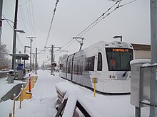
The fare for the S Line is the same as for TRAX[9] and the same methods of payment (including the FAREPAY card) are accepted.
The decision to use the same car model resulted in substantial savings as it allows UTA to use the same maintenance facilities used for TRAX.
[11] However, Mayor Becker suggested that as the S Line evolves (Phase 2 and beyond) the cars used could move "toward a more traditional streetcar design".
In late August 2013, UTA announced that the streetcar would be called the S Line According to UTA, "The S Line was named in honor of the streetcar's two founding cities, Salt Lake and South Salt Lake, as well as the Sugar House neighborhood it calls home.
"[11] Salt Lake City Mayor Ralph Becker stated, "The name both unites the communities, but also the corridor.
"[4] The line opened for regular service on December 8, 2013, but free rides were offered the day prior (with a food donation).
[3] Phase 1 of the S Line runs along the old D&RGW line (which lies between 2100 South and I-80) from the Central Pointe TRAX station in South Salt Lake to the commercial district of the Sugar House neighborhood of Salt Lake City near Highland Drive (specifically the site of the old Granite Furniture Building or "Granite Block").
[17][18] The streetcar plan was developed from an earlier proposal for a heritage trolley line which was begun in 2002.
[4][20] A two-block section of the S Line, between 300 and 500 East, was double-tracked in early 2019 at a cost of $5.9 million to address frequency needs spurred by growing ridership.
[14] In November 2023, UTA announced that construction on a 1,000-foot (300 m) extension to a new station on Simpson Avenue and Highland Drive.
[28] Notwithstanding, city leaders have repeatedly indicated that many of the objections arise because of a lack of understanding regarding the differences between the S Line (streetcar) and TRAX (light rail).
(Central Pointe is also the southernmost station served by all three TRAX lines: Blue, Red, and Green).
With industrial buildings on both sides of the track, the streetcar continues east to cross West Temple.
At West Temple, Parley's Tral begins running along the north side of the S Line for the remainder of the route.
[Note 2] East of South State Street the S Line begins a stretch with residential housing on the north side of the tracks instead of industrial buildings.
Heading north, but slightly to the west, the S Line will run through the commercial district along Highland Drive until it reaches 2100 South.
North of Ramona Avenue the streetcar leaves the commercial district and 1100 East has intermittent residential housing on both sides of the street.
Phase 2 will provide indirect service to Westminster College, the campus of which is just east of the end proposed S Line routing.
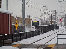
[3] Each passenger platform includes a small canopy (not much larger than a standard small bus stop shelter), a ticket vending machine and an electronic card reader (used for charging fares with UTA contactless transit passes or a contactless credit/debit cards by "tapping on" or "tapping off").