Sacramento Valley
Much wetter winters (averaging between 25–60 inches (640–1,520 mm) of annual precipitation in the nearby foothills) and an extensive system of irrigation canals allows for the economic viability of water-thirsty crops such as rice and Juglans hindsii-rootstock walnuts.
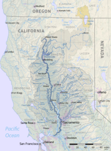
Rising in the various mountain ranges (the various Northern Coast Ranges to the west, the southern Siskiyou Mountains to the north, and the northern Sierra Nevada to the east) that define the shape of the valley, they provide water for agricultural, industrial, residential, and recreation uses.
[1] The terrain of the Sacramento Valley is primarily flat grasslands that become lusher as one moves east from the rain shadow of the Coast Ranges toward the Sierra.
Nicknamed the smallest mountain range in the world, it consists of the remnants of an extinct volcano and is located just outside Yuba City, 44 miles north of Sacramento.
Nuts, such as almonds and walnuts, are of greater importance north of the Delta, and rice, nonviable in the drier San Joaquin Valley, is a major crop.
The Sacramento Valley is also not as extensively cultivated; there are many more smallholdings and more uncultivated arable land compared to south of the Delta.
[4] In the summer, the "Delta Breeze", which comes in from the San Francisco Bay Area, is known for bringing cooler temperatures and higher humidity to the southern parts of the valley.
While it brings comparative relief for residents of Sacramento and Roseville, it often results in somewhat muggy conditions, with dew points sometimes reaching above 70 °F (21 °C) and occasionally pushing the heat index above 115 °F (46 °C) on the hottest days.
Lower-elevation snowfall (in a relative sense) is more consistent in the foothills immediately above Sacramento and Folsom than anywhere else in California; Pollock Pines at 3,980 feet (1,210 m), gets an average of 65 inches (170 cm) of snow every winter, nearly double that of Yosemite Valley and more than triple that of Lucerne, Switzerland.
During the rainy season, the Sacramento Valley is prone to strong thunderstorms and tornadoes, mostly of EF0 or EF1 intensity, especially in Colusa County and areas around Corning and Orland.
During the autumn and winter months, the entire Central Valley is susceptible to dense tule fog that makes driving hazardous, especially at night and especially south of Corning.
The Union Pacific Railroad serves the valley, with its principal north–south line from Oakland, California to Portland, Oregon, via Sacramento, Marysville, Chico, and Redding.