Sahara
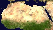
[4][5][6][7] The desert covers much of North Africa, excluding the fertile region on the Mediterranean Sea coast, the Atlas Mountains of the Maghreb, and the Nile Valley in Egypt and the Sudan.
[8] It stretches from the Red Sea in the east and the Mediterranean in the north to the Atlantic Ocean in the west, where the landscape gradually changes from desert to coastal plains.
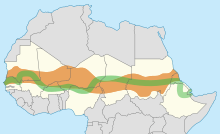
To the south it is bounded by the Sahel, a belt of semi-arid tropical savanna around the Niger River valley and the Sudan region of sub-Saharan Africa.
[17] To the south, the Sahara is bounded by the Sahel, a belt of dry tropical savanna with a summer rainy season that extends across Africa from east to west.
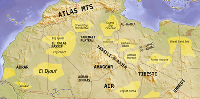
[17] Important cities located in the Sahara include Nouakchott, the capital of Mauritania; Tamanrasset, Ouargla, Béchar, Hassi Messaoud, Ghardaïa, and El Oued in Algeria; Timbuktu in Mali; Agadez in Niger; Ghat in Libya; and Faya-Largeau in Chad.
The effects of local surface low pressure are extremely limited because upper-level subsidence still continues to block any form of air ascent.
These major mountain ranges act as a barrier, causing a strong rain shadow effect on the leeward side by dropping much of the humidity brought by atmospheric disturbances along the polar front which affects the surrounding Mediterranean climates.
A value of 4300 hours (98%) of the time would be[clarification needed] recorded in Upper Egypt (Aswan, Luxor) and in the Nubian Desert (Wadi Halfa).
[22] Other hot spots in Algeria such as Adrar, Timimoun, In Salah, Ouallene, Aoulef, Reggane with an elevation between 200 and 400 metres (660 and 1,310 ft) above sea level get slightly lower summer average highs, around 46 °C (114.8 °F) during the hottest months of the year.
The vast central hyper-arid core of the desert is virtually never affected by northerly or southerly atmospheric disturbances and permanently remains under the influence of the strongest anticyclonic weather regime, and the annual average rainfall can drop to less than 1 millimetre (0.04 in).
[26] The annual average rainfall is virtually zero over a wide area of some 1,000,000 square kilometres (390,000 sq mi) in the eastern Sahara comprising deserts of: Libya, Egypt and Sudan (Tazirbu, Kufra, Dakhla, Kharga, Farafra, Siwa, Asyut, Sohag, Luxor, Aswan, Abu Simbel, Wadi Halfa) where the long-term mean approximates 0.5 millimetres (0.02 in) per year.
Following inter-pluvial arid periods, the Sahara area then reverts to desert conditions and the flora and fauna are forced to retreat northwards to the Atlas Mountains, southwards into West Africa, or eastwards into the Nile Valley.
[40] The growth of speleothems (which requires rainwater) was detected in Hol-Zakh, Ashalim, Even-Sid, Ma'ale-ha-Meyshar, Ktora Cracks, Nagev Tzavoa Cave, and elsewhere, and has allowed tracking of prehistoric rainfall.
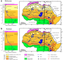
The moister Saharan conditions had begun about 12,500 BCE, with the extension of the ITCZ northward in the northern hemisphere summer, bringing moist wet conditions and a savanna climate to the Sahara, which (apart from a short dry spell associated with the Younger Dryas) peaked during the Holocene thermal maximum climatic phase at 4000 BCE when mid-latitude temperatures seem to have been between 2 and 3 degrees warmer than in the recent past.
Other animals include the monitor lizards, hyrax, sand vipers, and small populations of African wild dog,[55] in perhaps only 14 countries[56] and red-necked ostrich.
Researchers from Hacettepe University have reported that Saharan soil may have bio-available iron and also some essential macro and micro nutrient elements suitable for use as fertilizer for growing wheat.
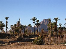
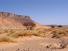
The modern Sahara, though, is not lush in vegetation, except in the Nile Valley, at a few oases, and in the northern highlands, where Mediterranean plants such as the olive tree are found to grow.
Shifts in Earth's axis increased temperatures and decreased precipitation, which caused an abrupt beginning of North Africa desertification about 5,400 years ago.
[78] During the Neolithic Era, before the onset of desertification around 9500 BCE, the central Sudan had been a rich environment supporting a large population ranging across what is now barren desert, like the Wadi el-Qa'ab.
By the 5th millennium BCE, the people who inhabited what is now called Nubia were full participants in the "agricultural revolution", living a settled lifestyle with domesticated plants and animals.
Subsistence in organized and permanent settlements in predynastic Egypt by the middle of the 6th millennium BCE centered predominantly on cereal and animal agriculture: cattle, goats, pigs and sheep.
In 4000 BCE, the start of sophisticated social structure (e.g., trade of cattle as valued assets) developed among herders amid the Pastoral Period of the Sahara.
The Libyco-Berber alphabet of the ancient Libyans of north Africa seems to have been based on Phoenician, and its descendant Tifinagh is still used today by the (Berber) Tuareg of the central Sahara.
The Periplus of the Phoenician navigator Hanno, who lived sometime in the 5th century BCE, claims that he founded settlements along the Atlantic coast of Africa, possibly including the Western Sahara.
It established regular air links from Toulouse (HQ of famed Aéropostale), to Oran and over the Hoggar to Timbuktu and West to Bamako and Dakar, as well as trans-Sahara bus services run by La Compagnie Transsaharienne (est.
[104] A remarkable film shot by famous aviator Captain René Wauthier in 1933 documents the first crossing by a large truck convoy from Algiers to Tchad, across the Sahara.
Most of the Saharan states achieved independence after World War II: Libya in 1951; Morocco, Sudan, and Tunisia in 1956; Chad, Mali, Mauritania, and Niger in 1960; and Algeria in 1962.
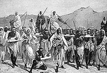
Other major groups of people include the: Toubou, Nubians, Zaghawa, Kanuri, Hausa, Songhai, Beja, and Fula/Fulani (French: Peul; Fula: Fulɓe).
[citation needed] Unlike neighboring West Africa and the central governments of the states that comprise the Sahara, the French language bears little relevance to inter-personal discourse and commerce within the region, its people retaining staunch ethnic and political affiliations with Tuareg and Berber leaders and culture.
[113] The legacy of the French colonial era administration is primarily manifested in the territorial reorganization enacted by the Third and Fourth republics, which engendered artificial political divisions within a hitherto isolated and porous region.