Sai Kung District
Areas in the district include Sai Kung Town, Hong Kong UNESCO Global Geopark, Tseung Kwan O and over 70 islands of different sizes.
The modern geopolitical entity of Sai Kung District was formed after World War II.
After the end of World War II (the author did not state the exact year, however), the New Territories was divided into 8 sub-divisions, one of which was named after Sai Kung.
[8] In 1977, the Hong Kong Governor announced to establish District Advisory Boards to invite locals to become advisors.
[13][14] Although Sai Kung locals, as well as other rural villages of the New Territories, already established their chambers and voting representatives to Heung Yee Kuk, an advisory body to the colonial government, as early as the 1930s.
A water route from the northern Sai Kung Peninsula to Tai Po existed at least since the Qing dynasty.
Sai Kung District covers approximately 130 square kilometres (50 sq mi) land area as of 2018,[17] It had a population of 461,864 in 2016 by-census,[2] most of it in Tseung Kwan O (398,479).
This was followed by the Tui Min Hoi (literal translation 'over the harbour') development under the government's market town programme.
The MTR metro system was extended to Tseung Kwan O, facilitating access to Sai Kung District.
[citation needed] Sai Kung remains only partly urbanised and is known as the "last back garden" of Hong Kong.
With the High Island Reservoir, High Island, Tai Long Wan, Pak Tam Au, Chek Keng, Sheung Yiu, Wong Shek Pier and the surrounding countryside, the 4,494 hectare protected area consists of the largest number of bays and coves among all country parks in Hong Kong.
Old preserved villages, such as Pak Sha O, Yung Shue O and Lai Chi Chong are the places of interest.
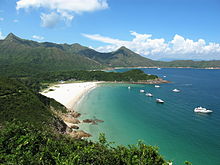
Sai Kung has some of the cleanest beaches in Hong Kong, including: On summer nights, many people hire small boats known as kaitos or sampan, some to catch cuttlefish which is a popular pastime for local residents, others for leisurely trips through the island-dotted inland sea of Port Shelter.
In recent years, the government has invested heavily in Sai Kung, with improvements being made to the town seafront, such as the Waterfront Park.
An attractive mix of small boutique-style shops has sprung up as well, due to a sizeable expat population and increasing numbers of local visitors, selling everything from secondhand books to cat-themed accessories, and alternative lifestyle stores that offer items like surfboards, candles, incense, seashells, etc.
The revitalisation of the old Centro Building, now renamed Dock 1A, a hub in Sai Kung located at 1A, Chui Tong Road is underway.
Previously the home of Tikitiki Bowling Alley and Bar, as well as a large supermarket, the complex will be transformed into a mega shopping mall with its grand opening is expected to happen in January 2025.
The Hong Kong Institute of Vocational Education has a campus [zh] in Tiu Keng Leng, Tseung Kwan O.
The magazine covers the areas of Sai Kung Town, Clear Water Bay, Pak Sha Wan and Ma On Shan.