Ho Chi Minh City
Beginning in the 1990s, the city underwent rapid expansion and modernization, which contributed to Vietnam's post-war economic recovery and helped revive its international trade hub status.
Currently, Ho Chi Minh City is facing increasing threats of sea level rise and flooding as well as heavy strains on public infrastructures.
Adrien Launay's Histoire de la Mission de Cochinchine (1688–1823), "Documents Historiques II: 1728 – 1771" (1924: 190) cites 1747 documents containing the toponyms: provincia Rai-gon, Rai-gon thong (for *Sài Gòn thượng "Upper Saigon"), & Rai-gon-ha (for *Sài Gòn hạ "Lower Saigon").
The proposal that Sài Gòn is from non-Sino-Vietnamese reading of Chinese 堤岸 ("embankment", tai4 ngon6, SV: đê ngạn)[nb 5], the Cantonese name of Chợ Lớn, (e.g. by Vương Hồng Sển) has been critiqued as folk-etymological, as: (1) the Vietnamese source Phủ biên tạp lục (albeit written in literary Chinese) was the earliest extant one containing the local toponym's transcription; (2) 堤岸 has variant form 提岸, thus suggesting that both were transcriptions of a local toponym and thus are cognates to, not originals of, Sài Gòn.
Saigon is unlikely to be from 堤岸 since in "Textbook on the Geography of the Southern Country", it also lists Chợ Lớn as 𢄂𢀲 separate from 柴棍 Sài Gòn.
In 1623, Lord Nguyen sent a mission to ask his son-in-law, King Chey Chettha II, to set up tax collection stations in Prey Nokor (Sài Gòn) and Kas Krobei (Bến Nghé).
In 1679, Lord Nguyễn Phúc Tần allowed a group of Chinese refugees from the Qing dynasty to settle in Mỹ Tho, Biên Hòa and Saigon to seek refuge.
In March, the Vietnamese expedition under Cảnh and a Chinese general Trần Thượng Xuyên (Chen Shangchuan) defeated the main Cambodian army at Bích Đôi citadel, king Chey Chettha IV took flight while his nephew Ang Em surrendered to the invaders, as the Vietnamese marched onto and captured Cambodia's capital Phnom Penh.
[29] Two years later, a large Vauban citadel called Gia Định, or Thành Bát Quái ("Eight Diagrams") was built by Victor Olivier de Puymanel, one of the Nguyễn Ánh's French mercenaries.
During the late 19th and early 20th centuries, construction of various French-style buildings began, including a botanical garden, the Norodom Palace, Hotel Continental, Notre-Dame Cathedral, and Bến Thành Market, among many others.
[41] The State officially became the Republic of Vietnam when Bảo Đại was deposed by his Prime Minister Ngô Đình Diệm in the 1955 referendum,[41] with Saigon as its capital.
[45] In the late 1950s, with the U.S. providing nearly $2 billion in aid to the Diệm regime, the country's economy grew rapidly under capitalism;[43] by 1960, over half of South Vietnam's factories were located in Saigon.
[42] In July 1976, upon the establishment of the unified communist Socialist Republic of Vietnam, the city of Saigon (including the Cholon area), the province of Gia Ðịnh and two suburban districts of two other nearby provinces were combined to create Ho Chi Minh City, in honour of the late Communist leader Ho Chi Minh.
[nb 6] At the time, the city covered an area of 1,295.5 square kilometres (500.2 sq mi) with eight districts and five rurals: Thủ Đức, Hóc Môn, Củ Chi, Bình Chánh, and Nhà Bè.
[50] On 29 October 2002, 60 people died and 90 injured in the International Trade Center building fire in Ho Chi Minh City.
[80] Various other nationalities including Koreans, Japanese, Americans, Russians, South Africans, Filipinos, French and Britons reside in Ho Chi Minh City as expatriate workers.
[96] The city and its ports are part of the 21st Century Maritime Silk Road that runs from the Chinese coast via the Suez Canal to the Mediterranean, there to the Upper Adriatic region of Trieste with its rail connections to Central and Eastern Europe.
The park is approximately 15 km (9 mi) from downtown Ho Chi Minh City and hosts software enterprises as well as dot.com companies.
Some 300,000 businesses, including many large enterprises, are involved in high-tech, electronic, processing and light industries, and also in construction, building materials and agricultural products.
The two most prominent projects are the Thủ Thiêm city centre in District 2 and the Phú Mỹ Hưng Urban Area, a new city centre in District 7 (as part of the Saigon South project) where various international schools such as Saigon South International School and Australian Royal Melbourne Institute of Technology are located.
[111] Bui Vien Walking Street is also well-known in Ho Chi Minh City due to its status as a hub for western backpackers and tourists.
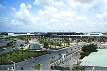
Based in Long Thành District, Đồng Nai Province, about 40 km (25 mi) east of Ho Chi Minh City, Long Thành Airport will serve international flights, with a maximum traffic capacity of 100 million passengers per year when fully completed; Tân Sơn Nhất Airport will serve domestic flights.
[118] The city's location on the Saigon River makes it a bustling commercial and passenger port; besides a constant stream of cargo ships, passenger boats operate regularly between Ho Chi Minh City and various destinations in Southern Vietnam and Cambodia, including Vũng Tàu, Cần Thơ and the Mekong Delta, and Phnom Penh.
[citation needed] Unlike other theatrical organisations found in Vietnam's provinces and municipalities, residents of the city keep their theatres active without the support of subsidies from the Vietnamese government.
Phú Thọ Racecourse, another notable sporting venue established during colonial times, is the only racetrack in Vietnam, however, due to poor maintenance, the facilities are not in good condition.
[147] The city's Department of Physical Education and Sport also manages a number of clubs, including Phan Đình Phùng, Thanh Đa, and Yết Kiêu.
Navibank Saigon F.C., founded as Quân Khu 4, were also based at Thống Nhất Stadium, emerged as champions of the First Division in the 2008 season, and were promoted to the V-League in 2009, the club has since been dissolved during a corruption scandal.
[148] The city's police department also fielded a football team in the 1990s, Công An Thành Phố, which won the V-League championship in 1995, the club was dissolved in 2002 as the league become more professional.
The city hosts a number of international sport events throughout the year, such as the AFF Futsal Championship and the Vietnam Vertical Run.
Several other sports are represented by teams in the city, such as Irish (Gaelic) Football, rugby, cricket,[151] volleyball, basketball, chess, athletics, and table tennis.


1–12. Districts 1 to 12 excludes District 2 and District 9 (Part of city of Thu Duc).
2. City of Thủ Đức
13. Bình Thạnh
14. Bình Tân
15. Gò Vấp
16. Phú Nhuận
17. Tân Bình
18. Tân Phú