Salem station (MBTA)
In January 1965, the 1964-formed Massachusetts Bay Transportation Authority (MBTA) began subsidizing some B&M suburban service, including the Eastern Route.
After a fire destroyed the bridge to Beverly in November 1984, the former rail yard at the north end of the tunnel was used as a temporary station to connect to buses, which replaced the northern branches of the line until December 1985.
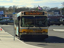
The station is fully accessible; a curved 800-foot (240 m)-long high-level side platform serves the single track of the Eastern Route on which the Newburyport/Rockport Line runs.
[6] Just south of the station, the track enters the 0.4-mile (0.64 km)-long Salem Tunnel, which runs under Washington Street through the downtown area.
A wooden station similar to those at Lynn and East Boston was soon constructed near Norman Street, with bells imported from Spanish churches.
[10][11]: 23 Salem was the terminus of the Eastern Railroad until December 18, 1839, when the extension to Ipswich opened as the first phase of the line's completion to Portsmouth, New Hampshire.
"[17] On June 16, 1846, the Eastern Railroad stockholders authorized the sale of $450,000 of new stock to fund various branch lines plus new depots at Salem and Lynn.
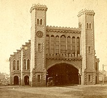
[14][11]: 35 [18] The Washington Street side of the new station had two towers, resembling those of a medieval castle, flanking a granite archway which spanned three tracks.
[11]: 36 In 1851, Nathaniel Hawthorne described the station in The House of the Seven Gables:[19] ...they now found themselves passing beneath the arched entrance of a large structure of gray stone.
Within, there was a spacious breadth, and an airy height from floor to roof, now partially filled with smoke and steam, which eddied voluminously upward, and formed a mimic cloud-region over their heads.The first 5 miles (8.0 km) of the Essex Railroad from Salem west to Danvers opened on January 19, 1847, with a wye connecting to the Eastern Railroad at the north end of the tunnel, and the remainder to North Andover in 1848.
[20][21] This was expanded into a large repair shop; the roundhouse was later rebuilt with more stalls and access from the south to serve commuter trains.
[23] Other minor passenger stations were located in Salem at various times: Grove Street, Carltonville, and North Street on the Essex Railroad; Castle Hill (Atlantic) at the junction of the Eastern and the Marblehead Branch; Pickman Park on the Eastern; and Loring Avenue and Forest River on the Marblehead Branch.
[23][12]: 309, 313 [24] On April 7, 1882, a fire resulting from an explosion of a can of fusees destroyed the wooden trainshed, although the granite facade and towers were intact.
[2]: 76 The tunnel flooded on several occasions, including 1898 and 1927, due to during high tides and storm surges on the North River.
It effectively extended the tunnel northwards by 350 feet (110 m), with separate north portals for the Eastern Route mainline and the Danvers Branch (ex-Essex Railroad).
[31] The Massachusetts Bay Transportation Authority (MBTA) was formed in August 1964 to subsidize suburban commuter rail service.
[12]: 317 Until 2023, Pan Am Railways operated limited local freight service through Salem via the tunnel, using the ex-Essex and ex-South Reading to reach the Rousselot Plant in Peabody.
[54] As part of environmental mitigation for increased urban auto traffic enabled by the Big Dig, the state was required to add 1,000 parking spaces to MBTA stations by the end of 2011.
[57][58] Major planning was completed in 2012, with community input leading to the addition of brick facades to match local architecture, as well as an indoor waiting room.
[60] Besides the garage, the project included the construction of a standard 800-foot (240 m)-long high-level platform for faster and fully accessible level boarding, as well as rehabilitation of the 1900-built interlocking tower.
[61] In early 2012, engineers found the remains of the roundhouse using ground penetrating radar while examining the site in preparation for the new parking garage.
[21] In November 2012, the MBTA closed part of the existing parking lot to excavate the remains, as required by the state Historical Commission.
[69] The waiting room had a tendency to flood during severe rains, a problem which the MBTA and the contractor began fixing in 2016 by adding a glass panel and new caulking.
[5] Although parking demand at Salem is high, approximately half of riders walk or bike to the station from nearby neighborhoods.
Reaching the station from these areas or an off-street lot along Bridge Street often involved crossing at an unsignalised crosswalk with poor visibility around a curve.
[8] Unofficial trails paralleling the two streets from the parking lot entrance were used by many pedestrians, but these routes were not accessible and involved trespassing on private land and/or the lightly used freight tracks.
[8] However, an official pedestrian route following the unofficial path north of the platform to the nearby Jefferson at Salem Station development was ruled out in March 2013 due to safety concerns, as it would have crossed the much busier mainline track.
[72][73][74] In 2020, to discourage crowding during the COVID-19 pandemic, this extra service was not run; most outbound trains did not stop at Salem for two weekends in late October.
[3] The MBTA has contemplated adding a branch line from Salem through Peabody, terminating near the Northshore Mall or the Danversport area of Danvers.
[78] As of 2024[update], a residential transit oriented development is planned to replace the remaining surface parking lot bordering Bridge Street.