Soil salinity control
This damage is an average of 2,000 hectares of irrigated land in arid and semi-arid areas daily for more than 20 years across 75 countries (each week the world loses an area larger than Manhattan)...To feed the world's anticipated nine billion people by 2050, and with little new productive land available, it's a case of all lands needed on deck.—principal author Manzoor Qadir, Assistant Director, Water and Human Development, at UN University's Canadian-based Institute for Water, Environment and Health[1] According to a study by UN University, about 62 million hectares (240 thousand square miles; 150 million acres), representing 20% of the world's irrigated lands are affected, up from 45 million ha (170 thousand sq mi; 110 million acres) in the early 1990s.
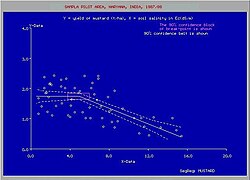
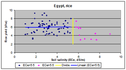
[1] In the Indo-Gangetic Plain, home to over 10% of the world's population, crop yield losses for wheat, rice, sugarcane and cotton grown on salt-affected lands could be 40%, 45%, 48%, and 63%, respectively.
[1] Salty soils are a common feature and an environmental problem in irrigated lands in arid and semi-arid regions, resulting in poor or little crop production.
Most of the water lost this way is stored underground which can change the original hydrology of local aquifers considerably.
Waterlogging causes three problems: Aquifer conditions in irrigated land and the groundwater flow have an important role in soil salinization,[3] as illustrated here: Normally, the salinization of agricultural land affects a considerable area of 20% to 30% in irrigation projects.
When the agriculture in such a fraction of the land is abandoned, a new salt and water balance is attained, a new equilibrium is reached and the situation becomes stable.
A regional distribution of the 3,230,000 km2 of saline land worldwide is shown in the following table derived from the FAO/UNESCO Soil Map of the World.
The main reason for this is the variation of natural conditions in time and space, the usually uneven distribution of the irrigation water, and the seasonal or yearly changes of agricultural practices.
The preparation of salt and water balances[3] for distinguishable sub-areas in the irrigation project, or the use of agro-hydro-salinity models,[5] can be helpful in explaining or predicting the extent and severity of the problems.
The discharge of salty drainage water may pose environmental problems to downstream areas.
The fluctuation of the water table helps in the breathing function of the soil while the expulsion of carbon dioxide (CO2) produced by the plant roots and the inhalation of fresh oxygen (O2) is promoted.
The establishment of the optimum depth of the water table is in the realm of agricultural drainage criteria.
In the Leziria Grande polder in the delta of the Tagus river in Portugal it was found that the leaching efficiency was only 0.15.
The desired soil salinity level Cd depends on the crop tolerance to salt.
[citation needed] The majority of the computer models available for water and solute transport in the soil (e.g. SWAP,[17] DrainMod-S,[18] UnSatChem,[19] and Hydrus[20]) are based on Richard's differential equation for the movement of water in unsaturated soil in combination with Fick's differential convection–diffusion equation for advection and dispersion of salts.
Further, the models are complicated to calibrate under farmer's field conditions because the soil salinity here is spatially very variable.
The models use short time steps and need at least a daily, if not hourly, database of hydrological phenomena.
Altogether, this makes model application to a fairly large project the job of a team of specialists with ample facilities.
Simpler models, like SaltMod,[5] based on monthly or seasonal water and soil balances and an empirical capillary rise function, are also available.
LeachMod,[21][22] Using the SaltMod principles helps in analyzing leaching experiments in which the soil salinity was monitored in various root zone layers while the model will optimize the value of the leaching efficiency of each layer so that a fit is obtained of observed with simulated soil salinity values.