Salt dome
Salt domes can have unique surface and subsurface structures, and they can be discovered using techniques such as seismic reflection.
[1] Over time, the layer of salt is covered with deposited sediment, becoming buried under an increasingly large overburden.
The vertical growth of salt formations creates pressure on the upward surface, causing extension and faulting.
These plugs can coalesce to form salt canopies, which can then be remobilized by roof sedimentation, with the most prominent example in the northern Gulf of Mexico basin.
These occur when the growth of a dome is prevented by an exhausted supply of salt, and the top and bottom contacts merge.
Seismic reflection highlights the presence of a stark density contrast between the salt and surrounding sediment.
[5] Advances in seismic reflection and the expansion of offshore petroleum exploration efforts led to the discovery of numerous salt domes soon after World War II.
[4][6] Several countries use solution mining to form caverns for holding large amounts of oil or gas reserves.
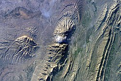
A Paradox Formation salt body that has risen as a ridge through several hundred meters of overburden, predominantly sandstone.
During the Messinian salinity crisis (Late Miocene), thick salt layers were formed as the Mediterranean Sea dried out.