Samoan Islands
The land masses of the two Samoan jurisdictions are separated by 64 km (40 mi; 35 nmi) of ocean at their closest points.
[1] The inhabitants have in common the Samoan language, a culture known as fa'a Samoa, and an indigenous form of governance called fa'amatai.
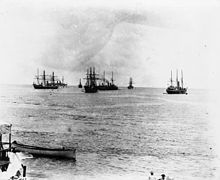
The force that eventually led to the political independence of the western islands in 1962 was the pro-independence Mau movement, which gained popularity across the area.
Tutuila is much smaller than Upolu and Savai‘i, at 136.2 km2 (52.6 sq mi) in area, but it is the largest island in American Samoa.
Another coral atoll, Swains Island, is within the territory of American Samoa but is geographically distant from the Samoan archipelago.
[24] By 2011, the government of independent Samoa decided to shift back to the western side in order to have the same day as Australia and New Zealand.
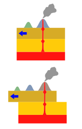
In theory, that hotspot was created by the movement of the Pacific tectonic plate over a 'fixed' deep and narrow mantle plume spewing up through the Earth's crust.
One piece of evidence that this activity may have created the islands is that they generally lie in a straight east-to-west line, and the plate is moving from east to west.
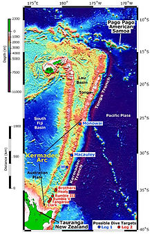
One possible explanation for the inconsistency of the data with the hotspot formation theory is the fact that the island chain lies just north of the Tonga Trench.
[28] The Vailulu'u Seamount, an active submerged volcano, lies 45 km (28 mi) east of Ta'u in American Samoa.
It was discovered in 1975 and has since been studied by an international team of scientists, contributing towards understanding of the Earth's fundamental processes.
[29] Growing inside the summit crater of Vailulu'u is an active underwater volcanic cone, named after Samoa's goddess of war, Nafanua.
The island group is frequently hit by tropical cyclones between December and March, due to its position in the South Pacific Ocean.