San Carlos, California
Prior to the Spanish arrival in 1769, the land of San Carlos was occupied by a group of Native Americans who called themselves the Lamchins.
When the Spanish arrived, they translated this as "the fleas", or "las Pulgas", giving many places and roads their modern names.
There were also grasses, plants and oak trees (for acorns), and archaeological finds of mortars and pestles indicate that these source were processed for food.
While early historians placed his approach to the Bay from the Pacific Ocean as coming over the San Carlos hills, present researchers believe this "discovery" actually occurred in present-day Belmont.
The Spanish, with overwhelming military and economic advantages over the native population, quickly dominated the Bay Area.
[13] Afterward, the land was deeded in large "ranchos", or ranches, to prominent and wealthy Spaniards, with no concern for the native populations that lived on them.
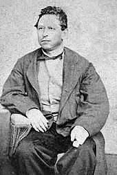
[citation needed] The land now occupied by the city of San Carlos was deeded as a single large rancho to Don José Darío Argüello.
José's son Luis Argüello was the first California-born governor of the state, and after his death in 1830 the remaining family moved to the ranch, now known as Rancho de las Pulgas.
The Argüello family retained deed to their ranch through the transfer of governments to the United States, and, in the 1850s, began selling parcels of it through their agent S. M. Mezes.
While the port of Redwood City, to the south, and the town of Belmont, to the north, both grew quickly in the late 19th century, San Carlos' growth was much slower.
Timothy Phelps, a wealthy politician, made an early attempt to further develop the San Carlos area.
He paid for significant improvements such as sewer lines and street grading, and began to promote lot sales in what he immodestly called "The Town of Phelps".
Some maps are existent referring to the area as "Lomitas" ("little hills" in Spanish) but eventually due to historical legend, the name "San Carlos" was chosen.
The newly named region—not yet incorporated—received a boost with the construction of the Peninsula Railroad Corridor in 1863, and the addition, of a station at San Carlos in 1888.
Growth remained slow through the turn of the 20th century, with most residents enjoying the short 35-minute train ride to San Francisco while living in a rural setting.
Many of the other residents which were not involved in agriculture were wealthy business and professional men who worked with the railroad or in San Francisco.
Despite the efforts of the developers, growth was very slow in this period, and San Carlos ended the 19th century with fewer than one hundred houses and families.
Cedar, Elm, Laurel, Magnolia, Maple (renamed El Camino Real) and Walnut were put down in this time.
Growth remained slow through the first fifteen years of the new century, but in 1918 the town had grown enough to build a school at 600 Elm Street.
The Great Depression affected families in San Carlos, as it did everywhere, but growth continued, and population grew from approximately 600 at incorporation in 1925 to 5,000 in 1941.
This innovation laid the groundwork for advancements in electronics and communications, making the company a key precursor to Litton Industries in 1953.
[15] While services such as stores increased in this period, by the beginning of World War II San Carlos was still known in the Bay Area as a rural community.
Most of the land in the municipality was still used for agricultural purposes, and photographs of the time show a landscape with few houses separated by large fields.
They left via San Francisco aboard the Liberty ship SS John Isaacson for assignments in the Pacific Theatre.
In 1950, when the population was 14,371, the city boasted a total of 89 industries: wholesalers, manufacturers and distributors, producing a variety of commodities from electronics to cosmetic.
San Carlos is home to a sculpture titled "Balancing Act" by artist James Moore, in front of Frank D. Harrington park on Laurel Street, which is often decorated for various holidays and local events.
The playing fields were kept and converted into Highlands Park, which now hosts many local youth sporting groups, while the school was replaced with new housing.
By the late 1990s and early first decade of the 21st century, city demographics changed again to a new generation of younger families with children, with the concurrent growth in student populations a new challenge for local schools.
In 2002, the city began experimenting with a free shuttle bus service named SCOOT, short for San Carlos Optimum Operational Transit, to help with transportation difficulties for those living in the hills of the town, and especially to make up for a lack of school buses.
However, voters rejected a parcel tax that placed 100% of the financial burden on property owners and the SCOOT program was dismantled on June 17, 2005.