San Dimas, California
San Dimas is bordered by the San Gabriel Mountains range to the north, Glendora and Covina to the west, La Verne to its north and east side, Pomona to its south and east side, Walnut and the unincorporated community of Ramona to the southwest, and the unincorporated community of West San Dimas, which is an enclave in the southwestern portion of the city.
The first known European exploration of the area was in 1774, when Juan Bautista de Anza passed through on the first overland expedition of Las Californias, from New Spain-Mexico towards Monterey Bay.
The area was originally developed in 1837 with the Mexican land grant from Governor Juan Bautista Alvarado to Ygnacio Palomares and Ricardo Vejar for the Rancho San Jose, then in Alta California.
In the early 1860s, a severe drought decimated the ranch's population of sheep and cattle.
Ygnacio Palomares died in 1864, and his widow began selling the ranch land in 1865.
Vejar lost his share by foreclosure to two Los Angeles merchants, Isaac Schlesinger and Hyman Tischler, in 1864.
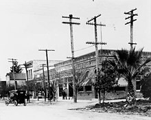
[14][15] The ensuing land boom resulted in the formation of the San Jose Ranch Company, which first laid out streets.
Small businesses began to open soon thereafter, and the city took on a new name: San Dimas.
Wheat and other Midwestern United States crops were planted first; then orange and lemon groves covered the town and the San Gabriel Valley.
At one time, four citrus packing houses and a marmalade factory were located in San Dimas.
San Dimas incorporated as a city in 1960, and is now known for its Western art, small-town feel, and equestrian qualities.
[16][17] In the 1990s, San Dimas was also host to the Miss Rodeo California State Pageant,[18] run by A. F. "Shorty" Feldbush and various other city volunteers.
San Dimas is a suburb of Los Angeles County nestled along the foothills of the San Gabriel Mountains, about 28 miles (45 km) east/northeast of downtown Los Angeles and north of the Pacific Ocean.
San Dimas runs along and southward from historic U.S. Route 66, another part of its development in the earlier 20th century.
Other major arteries include Arrow Highway (east–west) and San Dimas Avenue (north–south).
[32] The 2020 United States Census[40] reported that the population of San Dimas was 34,924 people with 11,396 households.
Of the total population, 6.9% of minors (those under the age of 18) and 11.3% of adults (those older than 18) were living below the poverty line.
Of the 12,506 housing units, at an average density of 810.6 per square mile (313.0/km2), 72.8% were owner-occupied, and 3,273 (27.2%) were occupied by renters.
According to the 2010 United States Census, San Dimas had a median household income of $78,685, with 6.6% of the population living below the federal poverty line.
Students living in the Via Verde neighborhood south of Puente Avenue and along San Dimas Avenue attend South Hills High School in the Covina-Valley Unified School District.
The city is also home to Life Pacific College, which is affiliated with the International Church of the Foursquare Gospel, offering undergraduate and graduate degrees.