San Gabriel River (California)
The Tongva and their ancestors inhabited the San Gabriel River basin for thousands of years at villages like Puvunga, relying on the abundant fish and game in riparian habitats.
Its water was heavily used for irrigation and ranching by Spanish, Mexican, and American settlers before urbanization began in the early 1900s, eventually transforming much of the watershed into industrial and suburban areas of greater Los Angeles.
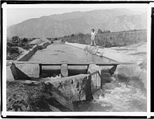
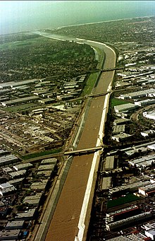
Severe floods in 1914, 1934, and 1938 spurred Los Angeles County, and later the federal government, to build a system of dams and debris basins and to channelize much of the lower San Gabriel River with riprap or concrete banks.
[9] Historically, the San Gabriel River reached its highest flows in the winter and spring, with runoff dropping significantly after early June before rising again with November or December storms.
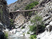
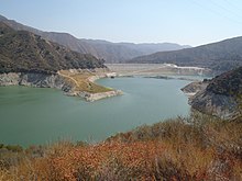
From World War II until the 1990s, Morris Reservoir was used by the U.S. Navy as a torpedo test site; the concrete launch ramp remains today and is easily seen from Highway 39, which runs through the canyon.
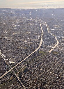
The usually-dry riverbed then continues in a southwesterly direction, passing the ruins of the 1907 Puente Largo or "Great Bridge" that once carried Pacific Electric interurban trains, and under Interstate 210 into the flood control basin behind Santa Fe Dam.
[27] During floods, the river transports large volumes of sediment from the mountains into the San Gabriel Valley, ranging from fine sands, gravels, clays, and silt to car-sized boulders.
[23] Prior to the development of the floodplain, the river channels down the alluvial slope were poorly-defined at best and frequently changed course with winter storms, leaping back and forth between several different ocean outlets.
At the southern end of the San Gabriel Valley, groundwater rose to the surface due to the damming effect of bedrock at the Whittier Narrows and formed a perennial stream that ran across the coastal plain to the Pacific.
In the 19th century, irrigated agriculture was developed on a large scale in the San Gabriel Valley, resulting in a severe decline of the water table as farmers drilled hundreds of wells.
The result of this overflow was a 47,000-acre (19,000 ha) network of riparian and wetland habitats, ranging from seasonally-flooded areas in the north to alkali meadows (called "cienegas" by the Spanish), forests of willows, oaks, and cottonwoods, and both fresh- and salt-water marshes in the south.
[29][30] At its mouth, the river emptied into a broad estuary surrounded by thousands of acres of permanent marsh and swamp land, the result of a band of bedrock running parallel to the coast, forcing groundwater to the surface.
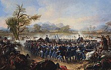
[49][54] Anthropologists believe the Tongva may have been some of the more advanced native inhabitants of California, establishing currency and complex trade systems with neighboring tribes, cultivating trees and plants for food, and having a formal government structure.
"[55] The abundant water available in the San Gabriel River basin, a rarity in arid Southern California, was noted by early Spanish explorers and made it an attractive place for Europeans to settle later on.
Juan Rodriguez Cabrillo sailed past the mouth of the San Gabriel River in 1542; although he did not land here, he did make contact with the native Tongva, who rowed out in their canoes to greet the expedition.
The one to the north is very high and dark and has many corrugations, and seems to run farther to the west.The expedition had to build a bridge across the river because the channel was too swampy and muddy, making it difficult to move their horses and supplies.
[59] Under the policy of reducción, the purpose being to "reduce or consolidate the Indians from the countryside into one central community",[57] the Spanish incentivized Native Americans to joining the mission system first via gifts, but also often by force.
Flumes were constructed to carry water to sluices, long toms, and hydraulic mining operations that separated gold from river gravel; dams and waterwheels helped maintain the necessary head to drive these extensive waterworks and clear the riverbed so that gold-bearing sands could be excavated.
Shacks, whiskey barrels, groceries, beds, roulette wheels, sluices, long toms, wing dams and China pumps were swept clean out of the mountains into the floodplain of the San Gabriel Valley.
A September 1932 Los Angeles Times article described it as a "leisurely gold rush"[69] and reported: Today there are slightly more than 500 persons scattered along the stream in the canyon, of which thirty are women and a score children.
After the founding of Mission San Gabriel, the Spanish built and gradually expanded a system of zanjas (canals) and reservoirs to irrigate crops, power mills, and water livestock.
[73] After California became part of the United States in 1846, the ranching economy gradually shifted towards agriculture (a transition quickened by the Great Flood of 1862 and subsequent drought of 1863-64 which killed almost three-quarters of the livestock in Los Angeles County),[74] and the San Gabriel River became a crucial water source for farms.
The California Gold Rush brought a huge influx of people to the state, and the high demand for food transformed the San Gabriel River Basin into one of the nation's most productive agricultural regions.
[63] Some areas had easy access to permanent water, such as the fertile "island meadow" region between the Rio Hondo and San Gabriel Rivers roughly where El Monte is today.
[89] When the Los Angeles Aqueduct opened that year, bringing water from the distant Owens Valley, it made possible the urbanization that would eventually replace the vast majority of farmland along the San Gabriel River.
[63] The creation of the Pacific Electric interurban railway system in 1911, by a merger of eight local streetcar companies, was a major factor in the growth of new communities along the San Gabriel River, by linking them with downtown Los Angeles.
[103] Weber's Camp, located in Coldwater Canyon (a tributary of the East Fork), was a popular stop along the route to the summit of Mount San Antonio, the highest point in the range.
The Cogswell, San Gabriel, and Morris dams are operated by the Los Angeles County Department of Public Works (LADPW) and can capture and store up to 85,000 acre-feet (105,000,000 m3) of rain and snow runoff.
[118] Although not directly related to water supply, the San Gabriel River bed – filled with coarse and fine sediments to depths of hundreds and sometimes thousands of feet – is an important source of aggregate materials (gravel and sand) for use in construction.
The San Gabriel Valley around Irwindale is one of the largest aggregate mining areas in the United States – more than a billion tons have been taken from the old river bed, supplying construction projects all over Los Angeles County.