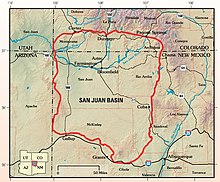
San Juan Basin
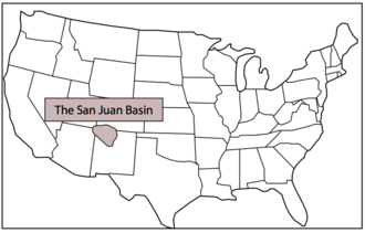
The basin covers 7,500 square miles and resides in northwestern New Mexico, southwestern Colorado, and parts of Utah and Arizona.
The San Juan Basin contains the largest coal-bed methane field in the world and ranks second in total gas reserves.
[2][3] During the mid-Paleozoic, the San Juan Basin was part of the ancient landmass called Laurentia; this was a supercontinent that contained much of current-day North America.
The Ouachita Orogeny was the collision of South America with the current-day Gulf-region, and resulted in the Ancestral Rockies - a northwest trending intercontinental mountain belt mainly through Texas, New Mexico, and Colorado.
[4][5] During the late Jurassic, continental collision of the Farallon and North American plates resulted in low-angle ("flat slab") subduction beneath the western margin of the United States.
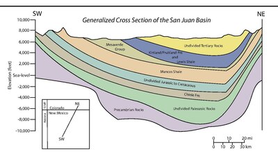
This began the transition from terrestrial sedimentation during the late Paleozoic and early Mesozoic to a shallow marine basin, as waters from the Arctic and Gulf regions poured into the center of the continent.
As compression shifted to extension and the formation of the Rio Grande Rift began, volcanism dominated the area throughout much of the Eocene and Oligocene.
[3][6] Prior to collision, Mississippian- and Pennsylvanian-aged units were deposited during various marine environments, e.g. the Leadville Limestone and the Pinkerton Trail Formations.
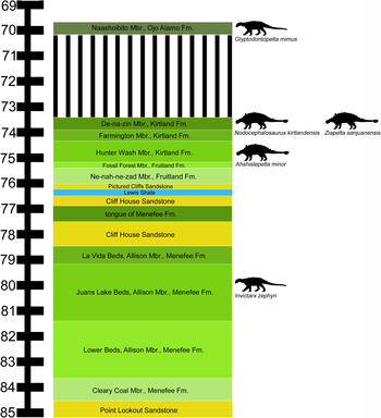
[4][5] The Cretaceous was a time of three major transgressive-regressive cycles, as eustatic changes in sea-level caused fluctuations on the Western Interior Seaway's shoreline.
maximum transgression) was recorded by the Lewis Shale, which eventually graded into the Pictured Cliffs and the Fruitland Formation as the shoreline made its final retreat.
Uplift in the northwest (and subsequent erosion), and continued deposition (e.g. the San Jose Formation) brought the basin to its current-day configuration.
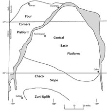
The Inner Cretaceous Seaway's western extent was along the San Juan Basin, and the three major transgressive-regressive episodes that occurred during this time are recorded in the mid- to upper-Cretaceous stratigraphy.
[2][3][7] The San Juan Basin contains ample fuel resources, including oil, gas, coal, and uranium.
The discovery was based on data from the European Space Agency’s Scanning Imaging Absorption Spectrometer for Atmospheric Chartography instrument from 2002 to 2012.
The region emitted 590,000 metric tons of methane every year between 2002 and 2012—almost 3.5 times the widely used estimates in the European Union’s Emissions Database for Global Atmospheric Research.