Colorado Plateau
This plateau covers an area of 336,700 km2 (130,000 mi2) within western Colorado, northwestern New Mexico, southern and eastern Utah, northern Arizona, and a tiny fraction in the extreme southeast of Nevada.
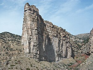
Domes, hoodoos, fins, reefs, river narrows, natural bridges, and slot canyons are only some of the additional features typical of the Plateau.
The Colorado Plateau has the greatest concentration of U.S. National Park Service (NPS) units in the country outside the Washington, DC metropolitan area.
North-south trending normal faults that include the Hurricane, Sevier, Grand Wash, and Paunsaugunt separate the section's component plateaus.
[2]: 366 This fault pattern is caused by the tensional forces pulling apart the adjacent Basin and Range Province to the west, making this section transitional.
A study of the area's unusually clear geologic history (laid bare due to the arid and semiarid conditions) has greatly advanced that science.
[2]: 374 A party from Santa Fe led by Fathers Dominguez and Escalante, unsuccessfully seeking an overland route to California, made a five-month out-and-back trip through much of the Plateau in 1776–1777.
[4] Despite having lost one arm in the American Civil War, U.S. Army Major and geologist John Wesley Powell explored the area in 1869 and 1872.
Using wooden oak boats and small groups of men, the Powell Geographic Expedition charted this largely unknown region of the United States for the federal government.
The lack of sediment has also starved sand bars and beaches, but an experimental 12-day-long controlled flood from Glen Canyon Dam in 1996 showed substantial restoration.
[5] The Precambrian and Paleozoic history of the Colorado Plateau is best revealed near its southern end, where the Grand Canyon has exposed rocks with ages that span almost 2 billion years.
[2]: 383 Erosion greatly reduced this mountain range before the encroachment of a seaway along the passive western edge of the continent in the early Paleozoic.
[2]: 383 Most of the formations were deposited in warm shallow seas and near-shore environments (such as beaches and swamps) as the seashore repeatedly advanced and retreated over the edge of a proto-North America (for detail, see geology of the Grand Canyon area).
Igneous rocks injected millions of years later form a marbled network through parts of the Colorado Plateau's darker metamorphic basement.
In late Paleozoic and much of the Mesozoic era the region was affected by a series of orogenies (mountain-building events) that deformed western North America and caused a great deal of uplift.
The Laramide orogeny closed the seaway and uplifted a large belt of crust from Montana to Mexico, with the Colorado Plateau region being the largest block.
Thrust faults in Colorado are thought to have formed from a slight clockwise movement of the region, which acted as a rigid crustal block.
It was along these ancient faults and other deeply buried structures that much of the province's relatively small and gently inclined flexures (such as anticlines, synclines, and monoclines) formed.
The Hopi Buttes in northeastern Arizona are held up by resistant sheets of sodic volcanic rocks, extruded about 7 million years ago.
The San Francisco Peaks near Flagstaff, south of the Grand Canyon, are volcanic landforms produced by igneous activity that began in that area about 6 million years ago and continued until 1064 CE, when basalt erupted in Sunset Crater National Monument.
These young igneous rocks may record processes in the Earth's mantle that are eating away at deep margins of the relatively stable block of the Plateau.
Yet for some reason not fully understood, the neighboring Colorado Plateau was able to preserve its structural integrity and remained a single tectonic block.
It was found that the asthenosphere had invaded the overlying lithosphere, as a result of an area of mantle upwelling stemming from either the disintegration of the descending Farallon Plate, or the survival of the subducted spreading center connected to the East Pacific Rise and Gorda Ridge beneath western North America, or possibly both.
This increased erosion at higher elevations with the introduction of alpine glaciers while mid-elevations were attacked by frost wedging and lower areas by more vigorous stream scouring.
The ITT Power Project, eventually located in Lynndyl, Utah, near Delta, was originally suggested for Salt Wash near Capitol Reef National Park.
Perhaps the only one of its kind, a gilsonite plant near Bonanza, southeast of Vernal, Utah, mines this unique, lustrous, brittle form of asphalt, for use in "varnishes, paints,...ink, waterproofing compounds, electrical insulation,...roofing materials.
"[11] This relatively high, semi-arid to arid province produces many distinctive erosional features such as arches, arroyos, canyons, cliffs, fins, natural bridges, pinnacles, hoodoos, and monoliths that, in various places and extents, have been protected.