San Mateo Creek (Southern California)
[4] One of the least developed watersheds on the South Coast, San Mateo Creek's drainage basin covers 139 square miles (360 km2) in parts of the Cleveland National Forest and Marine Corps Base Camp Pendleton.
The creek's usually perennial flow made it an important source of irrigation water, then in the later 19th century, there was a gold rush in the upper watershed.
The 22-mile (35 km)-long San Mateo Creek begins its course in a canyon in the extreme southeastern end of the Santa Ana Mountains, which lie mostly in Riverside County.
After running south for several miles it turns southeast to the Tenaja Falls where it tumbles down to its confluence with Los Alamos Canyon Creek, that comes in from the left.
Another unnamed arroyo drains the western Santa Rosa Plateau and the east slope of the Tenaja Mountain highland and descends to the north to join the creek where it turns to the west.
San Mateo Creek flows past Camp Pendleton, a United States Marine Corps amphibious training base.
[11] Geologically the San Mateo Creek watershed is dominated by the Santa Ana Mountains, whose underlying bedrock consists of Jurassic-age igneous and sedimentary rock, overlain by a few thousand vertical feet of Cretaceous-age granite, gabbro, and tonalite.
Underneath the San Mateo Creek valley's several hundred feet of alluvial deposits, there are layers of sandstone, limestone, siltstone, mudstone, shale and conglomerate.
These formations are present along most of the streams draining off the west slope of the Santa Ana Mountains and are practically identical as far north as Santiago Creek, which is in north-central Orange County nearly 50 miles (80 km) away.
[5][12] The alluvial deposits originate from the Wisconsinian glaciation, in which massive glaciers and ice sheets advanced over much of North America and shifted the global climate.
During this roughly 60,000-year-long period that ended in approximately 8000 B.C., Southern California received up to 80 inches (2,000 mm) of rainfall per year, and this radical climate change coincided with a 300-to-400-foot (91 to 122 m) drop in sea level.
Over the course of thousands of years, these calm inlets gradually filled with alluvial sediments, giving them the flat valley floors they have today.
[15] It shares boundaries with several watersheds – including Segunda Deshecha Cañada to the west, Arroyo San Onofre to the southeast, and streams draining into Lake Elsinore in the northeast.
Much of the upper San Mateo Creek watershed is encompassed by the central Cleveland National Forest and the lower lies mostly within Camp Pendleton.
These include riparian zones and woodlands around the perennial or semi-perennial streams, grassland on the valley floors, and chaparral and coastal sage scrub on the hillsides.
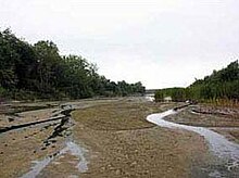
[18] Freshwater marshes surrounding San Mateo Creek exist in a strip just a few hundred feet wide and draw their water supply primarily from emerging groundwater.
There are also several species of burweeds and ferns, and on the edges of the marshes and on the surrounding small meadows, goldenrod, hedge-nettle, fleshy jaumea, Mexican rush, saltgrass, and iceplant.
[19] Steelhead have historically spawned in the creek, whose upper reaches also support a population of coastal rainbow trout, the stream resident form of O. m. irideus.
[20] Recently, steelhead have been sighted in the creek in greater numbers, bringing attention to coastal San Diego and Orange County streams.
[23] A report on the fauna of the county by Dr. David Hoffman in 1866 stated "Of the animal kingdom we have a fair variety: the grizzly bear, the antelope, the deer, the polecat, the beaver, the wildcat, the otter, the fox, the badger, the hare, the squirrel, and coyotes innumerable.
They planted non-native crops, pumped water from the aquifer, and grazed cattle, severely damaging the grasslands and riparian habitat.
By 1860, a discovery of gold, zinc, lead and silver in the upper San Mateo Creek watershed led American miners to the area.
While proponents of the project claim that it will relieve congestion on the interstate and not affect the native habitat,[33] opponents argue that the routing would increase sediment loads in the creek, damage the surf break at San Onofre State Beach, create water pollution and hurt several endangered animal species.