San Miguel Island
This westernmost Channel Island receives northwesterly winds and severe weather from the open ocean.
[6] San Miguel was occupied by the ancestors of the Chumash people for many millennia, who developed a complex and rich maritime culture based on marine fishing, hunting, and gathering.
The remains were studied before their return to the island, which was delayed by resolution of tribal identification and ownership issues contingent on the precedent setting Kennewick Man case in Washington State.
Under the Native American Graves Protection and Repatriation Act (NAGPRA), they were restored to the claiming Chumash tribe in May, 2018, for reburial on the island.
[7] A remaining population of a dwarf species descended from Columbian mammoths,[8] existed on Santarosae Island when it was first visited by Paleoindians, but were extinct for perhaps three millennia prior to the death of Tuqan Man.
[11] There is evidence of the fishing prowess of inhabitants using their tomols, and which included nets, spears, rods, lines, and hooks.
Two Chumash villages were active with about 100 inhabitants at the time of Cabrillo's visit in 1542 aboard the San Miguel.
The last of the island Chumash were removed to mainland missions and towns in the 1820s, leaving San Miguel largely uninhabited until ranchers raised sheep there from 1850 to 1948.
[13][4] George Nidever was the highest bidder for Samuel C. Bruce's property on the island in an auction held by the Santa Barbara County sheriff's office in June 1863.
In 1897, Waters formed the San Miguel Island Company with Jeremiah Conroy, consisting of 3000 sheep and other livestock.
However, the United States General Land Office ruled that no one had ever made claim to the island and that it remained in federal ownership.
[5]: 34–49 Despite a lighthouse on Richardson's Rock and a bell buoy, numerous ships continued to be wrecked on the island.
[5]: 49 During World War II, the United States Navy stationed three sailor lookouts on the island.
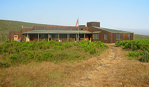
The National Park Service initiated a visitor program run by a resident ranger in 1978, but the navy retained ownership.
The Island is normally staffed by a ranger who enforces park laws, while also providing interpretive services for public visitors.
[22] Great white sharks, which prey on the seals and sea lions, are fairly common in the waters around the island,[16] hunted by orcas.
In May 2016, the island was reopened to tourism, following a two-year U.S. Navy survey over 18 miles (29 km) of marked trails and high-use areas.
Access permits are available at the boat and air concession offices and at a self-registration station at the Nidever Canyon trailhead on San Miguel Island.
During ideal weather, visitors are put ashore directly in front of the trail that leads into the interior of the island.
With the exception of the trail leading from the beach in Cuyler Harbor to the campground and ranger station, hiking is restricted to ranger-led outings.
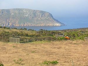
Many visitors participate in the 14-mile (23 km) round trip hike to Point Bennett to view the thousands of elephant seals and sea lions that reside at the west end of the island during spring and summer.
Bathers, divers and kayakers should be aware and alert to the occurrence of adult great white sharks in these waters, some up to 18 feet in length.