San Rafael Swell
The San Rafael Swell is a large geologic feature located in south-central Utah, United States about 16 miles (26 km) west of Green River.
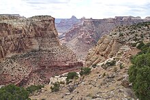
The San Rafael Swell, measuring approximately 75 by 40 miles (121 by 64 km), consists of a giant dome-shaped anticline of sandstone, shale, and limestone that was pushed up during the Paleocene Laramide Orogeny 40–60 million years ago.
Since that time, infrequent but powerful flash floods have eroded the sedimentary rocks into numerous valleys, canyons, gorges, mesas, buttes, and badlands.
The San Rafael Swell was formed when deeply buried Precambrian rocks faulted, or broke, during the Laramide orogeny, about 60 million years ago.
[1] Evidence of Native American cultures, including the Fremont, Paiute, and Ute, is common throughout the San Rafael Swell in the form of pictograph and petroglyph panels.
Although surrounded by the communities of Price, Green River, Hanksville, Ferron, Castle Dale, and Huntington, the Swell itself does not support permanent residents.
The idea of federal designation of the San Rafael Swell as a national monument resurfaced in 2010 in a US Department of the Interior document.
The San Rafael Swell attracts hikers, backpackers, horseback riders, trail runners and all-terrain vehicle (ATV) enthusiasts.