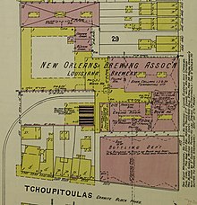
Sanborn maps
Sanborn employees, called "pasters" or "correctors", would visit subscribers' offices to paste the slips on top of the old maps.
In the late 18th century, insurance companies in London began to create detailed maps to give underwriters the information they needed to assess fire risk.
Factors such as the Homestead Act, railroad construction, the Second Industrial Revolution and massive immigration to the United States all fostered huge population growths, urbanization, and heightened demand for mapping.
Daniel Alfred Sanborn, a civil engineer and surveyor, began working on fire insurance maps in 1866.
In 1889 Sanborn acquired Perris and Browne, an older firm, and can by virtue of this expansion date its origins to 1852.
Company headquarters moved to 629 Fifth Avenue in northern Pelham, New York, but there were also regional offices in San Francisco, Chicago, and Atlanta.
At its peak in the 1920s, the company employed about 700 people, including about 300 field surveyors and 400 cartographers, printers, managers, salesmen, and support staff.
The Underwriter's Association of the Pacific complained that an "Eastern monopoly" was giving service that was "very slow, expensive, and generally unsatisfactory."
However, many insurance companies opposed the proposal, citing the "very large expenditure" required and their satisfaction with Sanborn's "commendably satisfactory" service.
In 1922, Sanborn agreed to add a member of the Map Committee to its Board of Directors, and a second seat was added by 1927.
This attracted the attention of the young Warren Buffett, who pressured the company to distribute the investment portfolio to shareholders.
[5] Buffett eventually purchased 23% of the company's outstanding shares as an activist investor, representing 35% of his investment partnership's total assets under management.
The Board agreed to buy back shares from any shareholder at fair value, paying with a portion of its investment portfolio.
Government sales began to play a larger role, especially the Census Bureau and municipal planning agencies.
[3] Over time, Sanborn diversified into other mapping activities, and as of 2020 is a geospatial specialist and holder of electronic GIS assets and systems, though the fire insurance business continues as a niche department.
Sanborn maps are found primarily in the archives and special collections of town halls and public and university libraries, and remain a resource for people in many different fields.