Santa Clarita Valley
The valley's main population center is the city of Santa Clarita which includes the neighborhoods of Canyon Country, Newhall, Saugus, and Valencia.
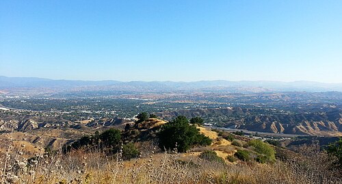
[1] The Santa Clarita Valley is bordered by the Lake Piru area, including the community of Val Verde, Los Padres National Forest, and Castaic Lake to the northwest, Sierra Pelona Mountains and Angeles National Forest to the north and northeast, San Gabriel Mountains to the east and southeast, and Santa Susana Mountains to the south and southwest, and Ventura County and the Santa Clara River Valley to the west.
The Santa Clarita Valley is underlain by Quaternary alluvial deposits and coarse-grained Pleistocene age conglomerates dominated by sandstone of marine and non-marine origin.
The southern end of Bouquet Canyon features a large areas of artificial fill stretching from Newhall Ranch Road up to Copper Hill Drive.
The much smaller Holser Fault runs east-to-west between the south-eastern Topatopa Mountains and the present day community of Valencia.
[6] Late spring and early summer mornings are often overcast due to the formation of a marine layer off the coast that moves inland overnight.
The valley is also home to a number of historical sites, such as the oil drilling town Mentryville, Walk of Western Stars, and William S. Hart Ranch and Museum.
The Santa Clarita Valley has a rich Western heritage, and since 1994, it has hosted an annual Cowboy Festival, which attracts more than 10,000 visitors each year.