Sarek National Park
The delta of the Rapa River is considered one of Europe's most noted views and the summit of mount Skierfe offers an overlook of that ice-covered, glacial, through valley.
[4] The most common Sami names for locations or features in the park are tjåkkå or tjåkko (mountain), vagge (valley), jåkkå or jåkko (stream), lako (plateau) and ätno (river).
Sarek National Park is situated in the Jokkmokk Municipality, Norrbotten County, Sweden, north of the Arctic Circle, 50 km (31.07 mi) from the Norwegian border.
[24] The Caledonian orogeny resulted from the collision of the Laurentia and Baltica plates, 450 to 250 million years ago, with the disappearance of the Iapetus Ocean by subduction.
[29] The glaciers began to grow and move into the valleys where they gradually merged to form an ice sheet that covered the entire region.
[30] The degree to which the chain was affected by the erosion depended mainly on the structure of the terrain, which explains the diversity in the topography of the area.
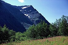
The topography of Sarek, similar to that of Kebnekaise, is divided into sharply defined zones, particularly in respect to the two neighbouring national parks.
[31] The park is intersected by a tangle of dikes created 608 million years ago, an era that probably corresponds with the first appearance of the rift during the formation of the Iapetus ocean.
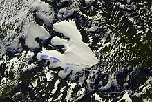
However, some of the others are relatively large for Sweden, since the largest Swedish glacier, Stuorrajekna in Sulitelma (south of Padjelanta), measures 13 km2 (5.0 sq mi).
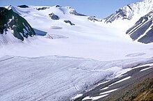
[30] The evolution of the glaciers, particularly that of the Mikka (8 km2 (3.1 sq mi))[34] have been studied since the end of the 19th century, especially by mineralogist and geographer Axel Hamberg.
[40] This is mainly explained by the fact that most of the park, except the south and south-east part,[7] is above the growth-limit of conifers,[40] which is at an altitude of about 500 m (1,600 ft) in this region.
[47] These forests are exceptional in terms of density and richness, making it possible for significant quantities of sediment material to be carried from the mountainside by the runoff and deposited in the watercourses.
[51] The division between the birch and coniferous forests is relatively blurred, with many of the animal species listed above also present in the subalpine zone.
[55] The willow warbler, the common redpoll, the brambling, the yellow wagtail, the northern wheatear and the bluethroat are characteristic of the birch forests.
[69] The number of lemmings varies extremely, with massive spikes in the population during some years, immediately followed by a very rapid decline.
This phenomenon is not completely understood; it appears that favourable weather, and therefore a surplus of food, results in sudden population growths, but the reason for the decline is less obvious, although it is certain that contagious diseases play some role.
However, the alpine zone has its own characteristic species, such as the rock ptarmigan,[69] the snowy owl, the horned lark, the meadow pipit, the snow bunting[70] and the Lapland longspur.
[74] Other rare species are also present, such as the lesser white-fronted goose, the great snipe, the red-throated pipit, the long-tailed duck and the bar-tailed godwit.
Due to the lack of shelters combined with rapidly shifting weather and rough terrain, it is recommended that hikers are well prepared and experienced before setting out on the trails of the park.
Warm weather increases the melting of the glaciers causing water levels to rise, therefore wading is often easier and safer early in the morning.
The lack of marked trails and accommodations makes it very difficult for visitors to hike in the park in winter, unless they are experienced and properly equipped.
The walls of the building were dry set from local stone and the roof was made of timber, transported from Kvikkjokk, 60 km (37 mi) away.
Pastavagge (in Lule Sami Orthography called Basstavágge) is a narrow valley, forming a pass, running from Pielavalta (Bielavallda) towards the east, ending north of Rinim on the shores of Lake Sitojaure (Sijddojávrre).
In Sweden, the polar explorer Adolf Erik Nordenskiöld became the first to propose using the new concept to protect areas of the Swedish landscape.
[104] In 1900, the association studied the possibility of creating a long hiking trail crossing the Lapland mountains, between Abisko and Kvikkjokk.
[105] The initial proposal was for a marked trail that passed through the park, a boat crossing of the Rapaselet and a mountain hut beside the river.
[107] This sudden success caused several problems such as the temporary overcrowding on certain trails in the Rapa Valley, which were not designed to accommodate so many visitors.
Such an incident occurred in 2007, when an unregistered wolf, a protected and endangered species in Sweden, wandered into an area in Tjåmotis (30 km (19 mi) southeast of the Rapa Valley) where reindeer were grazing.
The decision and the killing were made collectively by the Norrbotten County Administrative Board, the Environmental Protection Agency and the Sami in accordance with the national nuisance wildlife management act.
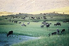
Joyrides by visitors outside the marked trails have become a problem, especially for the Sami, since they claim that the disruptions made by snowmobiles may cause the pregnant female reindeer to drop their calves prematurely.