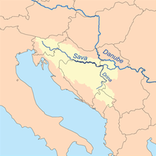
Sava
It drains a significant portion of the Dinaric Alps region, through the major tributaries of Drina, Bosna, Kupa, Una, Vrbas, Lonja, Kolubara, Bosut and Krka.
[8][9] The Sava Dolinka rises at the Zelenci Pools near Kranjska Gora, Slovenia, in a valley separating the Julian Alps from the Karawanks mountain range.
[13] The Sava Bohinjka originates in Ribčev Laz, at the confluence of the Jezernica,[14] a short watercourse flowing out from Lake Bohinj and the Mostnica River.
[26] The Sava Dolinka rises in the Zelenci Pools, west of Podkoren in the Upper Carniola region of Slovenia at 833 metres (2,733 feet) above sea level (a.s.l.
At Žirovnica, the river enters the Ljubljana Basin and encounters the first hydroelectric dam—Moste plant—before proceeding to the east of the glacial Lake Bled towards Radovljica and confluence of the Sava Bohinjka,[27] at 411 metres (1,348 feet) a.s.l.
The course through the Sava Hills forms the boundary of traditional regions of Lower Carniola and Styria,[34] At Radeče, the Vrhovo hydroelectric dam reservoir stands.
[41] As the Sava approaches the capital of Croatia, Zagreb, the marshes give way to urban landscape, but there are surviving examples of the gravel pit lakes, such as the Jarun,[42] and the Bundek within the city.
[46] East of Zagreb, the river turns southeast again further through the Central Croatia, to the Sisak-Moslavina County, the city of Sisak, reaching 91.3 metres (300 feet) a.s.l.
Its meandering course runs generally eastwards along Bosanska Gradiška, and Slavonski Brod to Županja, where it turns south to Brčko.
[11] Downstream from the confluence of the Drina, the Sava River changes its eastward course to northeast, until it reaches Sremska Mitrovica, whence it flows southeast and then south to Šabac, before finally turning east towards Belgrade.
as its right tributary at the Great War Island off the easternmost tip of Syrmia in Belgrade, 1,169.9 kilometres (726.9 miles) away from the Danube's confluence and the Black Sea.
[65] Other cities along the river, with populations of 20,000 and larger, are Slavonski Brod (53,473), Šabac (52,822), Sremska Mitrovica (37,586), Kranj (35,587),[66] Sisak (33,049),[61] Obrenovac (24,568),[67] and Bosanska Gradiška (est.
The uppermost course of the river and its headwaters in the Karawanks area, is in the Southern Alps, tracing the Sava Fault—itself running parallel to the Periadriatic Seam.
[97] The Pannonian Basin took shape through Miocenian thinning and subsidence of crust structures formed during Late Paleozoic Variscan orogeny.
[98] Ultimately, up to 3,000 metres (9,800 feet) of the sediment was deposited in the basin, and the Pannonian sea eventually drained through the Iron Gate gorge.
[99] In the southern Pannonian Basin, the Neogene to Quaternary sediment depth is normally lower, averaging 500 to 1,500 metres (1,600 to 4,900 feet), except in central parts of depressions formed by subduction.
The plains are interspersed by the horst and graben structures, believed to have broken the Pannonian Sea surface as islands,[101] which became watershed between Drava and Sava River basins extending along Ivanščica–Kalnik–Bilogora–Papuk mountain chain.
[104] The loess plateau, extending eastward from Dilj and representing the watershed between the Vuka and Bosut rivers, gradually rises to the Fruška Gora south of Ilok.
There are also plans for construction of ten new powerplants in the middle Sava valley HE Suhadol, HE Trbovlje, HE Renke, HE Ponovice, HE Kresnice, HE Jevnica, HE Zalog, HE Šentjakob, HE Ježica and HE Tacen.
[119] The largest ports on the Sava River are Brčko and Šamac in Bosnia-Herzegovina,[120] Sisak and Slavonski Brod in Croatia,[121] and Šabac and Sremska Mitrovica in Serbia.
[122] As of 2008[update], 24.5 kilometres (15.2 miles) of the river course between Slavonski Šamac and Oprisavci, as well as additional 219.8 kilometres (136.6 miles) between Slavonski Brod and Sisak, are considered by Croatia's Ministry of Maritime Affairs, Transport and Infrastructure to fail the Class IV criteria, permitting navigation of vessels up to 1,000 tonnes (980 long tons; 1,100 short tons) only, complying with the AGN's Category III.
Similar interruptions are less frequent elsewhere on the river, occurring 30 days a year on average upstream from Oprisavci, and even more rarely downstream from Slavonski Šamac.
The plan aims to increase the safety and volume of river transport, which declined by about 70% since the breakup of Yugoslavia, largely because of poor maintenance of the route.
[137] Agriculture is another significant source of the Sava River basin surface water pollution, specifically through livestock manure production.
[141] Levels of heavy metals, specifically zinc, copper, lead and cadmium, measured in sediments in the Sava River near Belgrade were assessed as representing little to no risk,[dubious – discuss] and the conclusion drawn was that in order to "reduce the existing bacterial contamination of the Sava River it is necessary to control faecal discharge near cities like Belgrade.
"[142] The two countries (Croatia and Montenegro) with the greatest direct access to the Adriatic showed by far the least polluted basin surface waters, although other factors, such as demography, agricultural/environmental development and, especially, investment (internal and external), play a role.
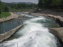
[146] In Zagreb, Jarun complex of lakes along the river course offers a range of facilities for swimming, water sports and cycling.
[147] The island of Ada Ciganlija in Belgrade is the major recreational zone of the city, gathering as many as 100,000 visitors daily in the summer months.
However, the two wavy lines at the base of the blazon officially represent rivers of Slovenia and the Adriatic Sea rather than the Savica or the Sava specifically.
The design, approved by the Vladislaus II of Bohemia and Hungary in 1496, incorporates two bars symbolising the Sava and the Drava rivers tracing the borders of the kingdom.