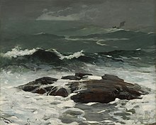
Seascape
It is applied in planning contexts to geographical locations possessing a good view of the sea.
In modern times, seascapes have endured partially in depictions of maritime works of art, as well as views of the sea.
In the UK a seascape is defined in planning and land use contexts as a combination of adjacent land, coastline and sea within an area, defined by a mix of land-sea inter-visibility and coastal landscape character assessment, with major headlands forming division points between one seascape area and the next.
This approach to coastal landscape planning was developed jointly by Government environmental bodies in Wales (UK) and Ireland in 2000 to assist spatial planning for (at that time new) offshore wind farm developments.
The resulting "Guide to best practice in seascape assessment"[3] (Marine Institute, Ireland, 2001), have since been adapted and applied in Scotland[4] and Wales[5] for guidance to offshore wind farm developers and for carrying out spatial planning assessments.