Sedimentary basin
[1][2][3] They form when long-term subsidence creates a regional depression that provides accommodation space for accumulation of sediments.
As the sediments are buried, they are subject to increasing pressure and begin the processes of compaction and lithification that transform them into sedimentary rock.
[5] Sedimentary basins are created by deformation of Earth's lithosphere in diverse geological settings, usually as a result of plate tectonic activity.
Mechanisms of crustal deformation that lead to subsidence and sedimentary basin formation include the thinning of underlying crust; depression of the crust by sedimentary, tectonic or volcanic loading; or changes in the thickness or density of underlying or adjacent lithosphere.
Trenches form in the deep ocean but, particularly where the overriding plate is continental crust they can accumulate thick sequences of sediments from eroding coastal mountains.
They tend to be subcircular in shape and are commonly filled with shallow water marine or terrestrial sedimentary rocks that remain flat-lying and relatively undeformed over long periods of time due to the long-lived tectonic stability of the underlying craton.
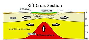
The lower, hotter part of the lithosphere will "flow" slowly away from the main area being stretched, whilst the upper, cooler and more brittle crust will tend to fault (crack) and fracture.
The combined effect of these two mechanisms is for Earth's surface in the area of extension to subside, creating a geographical depression which is then often infilled with water and/or sediments.
An example of a basin caused by lithospheric stretching is the North Sea – also an important location for significant hydrocarbon reserves.
Another such feature is the Basin and Range Province which covers most of Nevada, forming a series of horst and graben structures.
Lithospheric flexure is another geodynamic mechanism that can cause regional subsidence resulting in the creation of a sedimentary basin.
Analogous to a solid floating in a liquid, as the lithospheric plate gets denser it sinks because it displaces more of the underlying mantle through an equilibrium process known as isostasy.
In strike-slip tectonic settings, deformation of the lithosphere occurs primarily in the plane of Earth as a result of near horizontal maximum and minimum principal stresses.
Regional study of these rocks can be used as the primary record for different kinds of scientific investigation aimed at understanding and reconstructing the earth's past plate tectonics (paleotectonics), geography (paleogeography, climate (paleoclimatology), oceans (paleoceanography), habitats (paleoecology and paleobiogeography).
Sedimentary basin analysis is thus an important area of study for purely scientific and academic reasons.
The scientific studies of stratigraphy and in recent decades sequence stratigraphy are focused on understanding the three-dimensional architecture, packaging and layering of this body of sedimentary rocks as a record resulting from sedimentary processes acting over time, influenced by global sea level change and regional plate tectonics.
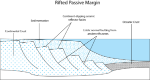
Much of a sedimentary basin's fill often remains buried below the surface, often submerged in the ocean, and thus cannot be studied directly.