Seerhein
Rheinsee) is a river about 4.3 km (2.7 mi) long, in the basin of Lake Constance (German: Bodensee).
Some time after this period, the water level of Lake Constance gradually dropped by about ten metres and the shallow parts fell dry.
The Seerhein has two creeks as tributaries, both on the left side: the Dorfbach near Gottlieben and the Grenzbach ("Border Brook") on the western city limits of Constance.
Tägermoos is politically in the Swiss municipality of Tägerwilen, but the City of Constance participates in its administration.
This valley is bordered on the south by the Seerücken (English: Lake Ridge) and to the north from the hill country of the Bodanrück peninsula.
In a Swiss list of regions, Schilter included the Seetal in the Uferlandschaft ("River Bank Area"), which stretches all the way to Romanshorn.
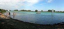
[2] The Seerhein is navigable and is used primarily by the pleasure boats of the "Schweizerischen Schifffahrtsgesellschaft Untersee und Rhein" ("Swiss Shipping Company 'Untersee and Rhine').
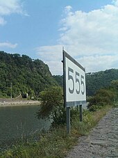
In the 19th century, distance markers where placed along the Rhine; they start counting Kilometres at the Old Bridge in Constance.
The entire landscape of the Seerhein and its environment is in the range of Molasse basin, which was formed during the Upper Miocene about 30 million years ago.
The lowlands surrounding the Seerhein are largely the result of siltation and is one of the basin landscapes; the neighbouring hill ranges Bodanrück and Seerücken are glacial molasses highlands.
[4] A decisive step in the formation of today's Seerhein and Lake Constance area took place with the deflection of the Alpine Rhine from the Danube to the Aar during Günz ice age.
[5] The retreat of the Rhine glacier (at the end of the Würm ice age) occurred as a number of melting and stationary phases, which are conventionally divided into nine stages.
The ice edge east of the glacier was along a line from the Lake Überlingen via the eastern tip of Bodanrück, through Constance and Kreuzlingen to the northern end of the Seerücken.
Early in the Constance stage, a proglacial lake formed in the area of today's Seerhein basin and to the west of it.
After the Ice lake disappeared, a terminal moraine was formed, which later turned out to be important for the course of human settlement (see below).
In Kreuzlingen, the moraine extends along the Hauptstrasse ("Main Street"), roughly from the border to the intersection with Remisbergstrasse.
In the context of the two-part Lake Constance, the Seerhein present a suitable point to construct a bridge or a ferry and to found a port town.
The monastery was founded on the opposite bank of the Seerhien, by analogy with St. Peter's basilica in Rome, with was built on the "other" side of the Tiber.
Fishermen on the Lower Lake reported that the water of the Rhine appeared to flow backwards.
Today, this event can be explained scientifically: Certain wind conditions induce waves at the natural frequency of the upper and lower lake.
This creates a seiche, i.e. standing wave, in which the entire lake resonates at its natural frequency.