Reflection seismology
[1] The use of human-generated seismic waves to map in detail the geology of the upper few kilometers of the Earth's crust followed shortly thereafter and has developed mainly due to commercial enterprise, particularly the petroleum industry.
[2] After WWI, those involved in the development of commercial applications of seismic waves included Mintrop, Reginald Fessenden, John Clarence Karcher, E. A. Eckhardt, William P. Haseman, and Burton McCollum.
In the case of reflection seismology, the experimental data are recorded seismograms, and the desired result is a model of the structure and physical properties of the Earth's crust.
In turn, they use this information to infer changes in the properties of the rocks at the interface, such as density and wave velocity,[4] by means of seismic inversion.
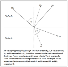
The situation becomes much more complicated in the case of non-normal incidence, due to mode conversion between P-waves and S-waves, and is described by the Zoeppritz equations.
Practical use of non-normal incidence phenomena, known as AVO (see amplitude versus offset) has been facilitated by theoretical work to derive workable approximations to the Zoeppritz equations and by advances in computer processing capacity.
[13] The Scholte wave is similar to ground roll but occurs at the sea-floor (fluid/solid interface) and it can possibly obscure and mask deep reflections in marine seismic records.
Examples of this environment are river deltas, swamps and marshes,[27] coral reefs, beach tidal areas and the surf zone.
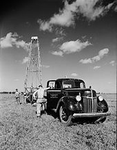
Vibroseis is a non-impulsive source that is cheap and efficient but requires flat ground to operate on, making its use more difficult in undeveloped areas.
The method comprises one or more heavy, all-terrain vehicles lowering a steel plate onto the ground, which is then vibrated with a specific frequency distribution and amplitude.
For a long time, it was the only seismic source available until weight dropping was introduced around 1954,[32] allowing geophysicists to make a trade-off between image quality and environmental damage.
Attempts have been made to use multiple seismic sources at the same time in order to increase survey efficiency and a successful example of this technique is Independent Simultaneous Sweeping (ISS).
This led to another variation on the NATS survey type, the wide-azimuth towed streamer (or WAZ or WATS) and was first tested on the Mad Dog field in 2004.
This method was originally developed out of operational necessity in order to enable seismic surveys to be conducted in areas with obstructions, such as production platforms, without having the compromise the resultant image quality.
In 2005, ocean bottom nodes (OBN) – an extension of the OBC method that uses battery-powered cableless receivers placed in deep water – was first trialled over the Atlantis Oil Field in a partnership between BP and Fairfield Geotechnologies.
[42] The placement of these nodes can be more flexible than the cables in OBC and they are easier to store and deploy due to their smaller size and lower weight.
The ocean bottom hydrophone concept itself is not new and has been used for many years in scientific research, but its rapid use as a data acquisition methodology in oil and gas exploration is relatively recent.
Their physical dimensions vary depending on the design requirement and the manufacturer, but in general nodes tend to weigh in excess of 10 kilograms per unit to counteract buoyancy issues and to lessen the chance of movement on the seabed due to currents or tides.
If too many nodes are deployed and the OBN crew's resources are not sufficient to recover these in time or external factors such as adverse weather limits recovery operations, batteries can expire and data can be lost.
Node on a rope is normally used where there is shallow water within the prospect, for example less than 100 metres or a transition zone area close to a beach.
Time lapse surveys are acquired in order to observe reservoir changes during production and identify areas where there are barriers to flow that may not be detectable in conventional seismic.
[45] This process improves temporal resolution by collapsing the seismic wavelet, but it is nonunique unless further information is available such as well logs, or further assumptions are made.
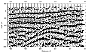
This allows a geophysicist to construct a group of traces with a range of offsets that all sample the same subsurface location, known as a Common Midpoint Gather.
The effort produced some significant results and showed that it is possible to profile features such as thrust faults that penetrate through the crust to the upper mantle with marine seismic surveys.
[52] As with all human activities, seismic reflection surveys have some impact on the Earth's natural environment and both the hydrocarbon industry and environmental groups partake in research to investigate these effects.
In addition to whales, sea turtles, fish and squid all showed alarm and avoidance behaviour in the presence of an approaching seismic source.
It is difficult to compare reports on the effects of seismic survey noise on marine life because methods and units are often inadequately documented.
Even so, airguns are shut down only when cetaceans are seen at very close range, usually under 1 km[56] Offering another point of view, a joint paper from the International Association of Geophysical Contractors (IAGC) and the International Association of Oil and Gas Producers (IOGP) argue that the noise created by marine seismic surveys is comparable to natural sources of seismic noise, stating:[57] The UK government organisation, the Joint Nature Conservation Committee (more commonly known as JNCC) is "...the public body that advises the UK Government and devolved administrations on UK-wide and international nature conservation.
Even back in the 1990s, it was understood at a government level that the impact of the sound energy produced by seismic surveys needed to be investigated and monitored.
Further research in reflection seismology may be found particularly in books and journals of the Society of Exploration Geophysicists, the American Geophysical Union, and the European Association of Geoscientists and Engineers.