Seram Island
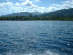
Seram is traversed by a central mountain range, the highest point of which, Mount Binaiya, is covered with dense rain forests.
Meanwhile, along with the northward push of the Australian Plate, this has resulted in the uplift that gives north-central Seram peaks of over 3000 m. On the island, there are important karst areas.
The largest and most dangerous to humans is the saltwater crocodile, found within the island's coastal brackish waters and deltas; some are known to swim inland via freshwater routes, such as the Salawai River.
[13][14] In the fifteenth and sixteenth centuries, Seram was generally within the sphere of influence of Ternate, although it was often ruled more directly by the Ternaten vassal state of Buru.
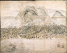
The expedition of António de Abreu (as captain) and Francisco Serrão sighted and explored the entire southern coast of Seram in early 1512, for the first time for Europeans.
[16] From 1954 until 1962 the island's mountain terrain was the scene of an armed guerilla struggle against Indonesian rule by the counter revolutionary Republic of South Moluccas movement led by Soumokil.
Seram has been peaceful for many years but towns like Masohi remain informally divided into de facto Christian and Muslim sections.
[25] The Oseil oil field is located onshore in the northeast of the island in the Seram Non-Bula Production Sharing Contract area.