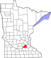
Shakopee, Minnesota
Sited on the south bank bend of the Minnesota River, Shakopee and nearby suburbs comprise the southwest portion of Minneapolis-Saint Paul, the nation's 16th-largest metropolitan area, with 3.7 million people.
[3] The riverbank's Shakopee Historic District contains burial mounds built by prehistoric cultures.
In the 18th century, Chief Shakopee of the Mdewakanton Dakota established his village on the east end of this area, near the water.
Shakopee boomed as a commerce exchange site between river and rail at Murphy's Landing.
Shakopee was once an isolated city in the Minnesota River Valley, but by the 1960s its economy was tied to that of the expanding metropolitan area.
Significant growth as a bedroom community occurred after U.S. Highway 169 was realigned in 1996 toward the new Bloomington Ferry Bridge.
[6] Burial mounds along the Minnesota River bluff, within the present-day Veterans Memorial Park, are between 500 and 2,000 years old.
The Shakopee band lived in summer bark lodges and winter tipis.
The latter people had moved south to what was later assigned to them as the Shakopee-Mdewakanton Indian Reservation in nearby Prior Lake.
County Highway 101 serves as a major east–west connector route of historic downtown Shakopee.
[19] Shakopee has a campus of the Globe University/Minnesota School of Business, a private career college.