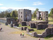
Shane's Castle
Built in 1345 by a member of the Clandeboy O'Neill dynasty, it was originally known as Edenduffcarrick, meaning "brow of black rock" (from the Irish éadán dúcharraige).
It was laid by NIR staff in their spare time using 75 pounds per yard (37 kg/m) track with curves to CDRJC standards and opened on 30 April 1971.
The line had three stations (Antrim, Millburn and Shane's Castle) and was 1 mile 40 chains (2.4 km) long.
It closed on 31 October 1995 due to declining visitor numbers[7][8][9] There had previously been a 2 ft (610 mm) gauge line in the castle grounds between 1940 and 1956, which was used by the British Army for transport to and from a bomb dump.
You can help Wikipedia by expanding it.This article related to the geography of County Antrim, Northern Ireland is a stub.